Omaha Fire Station #22
Omaha Fire Station #22 is a fire station in City of Omaha, Douglas, Nebraska which is located on Lindbergh Drive. Omaha Fire Station #22 is situated nearby to the aerodrome Eppley Airfield, as well as near the town Carter Lake.| Tap on a place to explore it |
- Type: Fire station
- Description: fire station in Omaha, Nebraska
- Also known as: “Omaha Fire Department Station 22”
- Address: 8310 Lindbergh Drive, Omaha, NE 68110
Places of Interest Nearby
Highlights include Eppley Airfield and Sherman Elementary School.
Eppley Airfield
Aerodrome
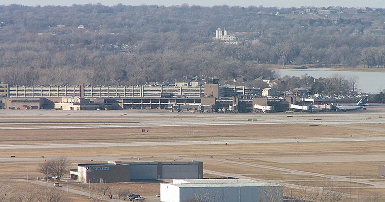
Photo: Americasroof, CC BY-SA 2.5.
Eppley Airfield, also known as Omaha Airport, is an airport in the midwestern United States, located three miles northeast of downtown Omaha, Nebraska.
Sherman Elementary School
School
Sherman Elementary School is located at 5618 North 14th Avenue in East Omaha, Nebraska, United States. Founded in 1888 at 16th and Jaynes Streets for 21 students, today Sherman is home to over 275 students in prekindergarten through sixth grade. Sherman Elementary School is situated 1 mile west of Omaha Fire Station #22.
North Omaha Power Station
Power station

Photo: Wikimedia, Public domain.
North Omaha Power Station is situated 2 miles northwest of Omaha Fire Station #22.
Places in the Area
Nearby places include Carter Lake and Omaha.
Carter Lake
Town
Photo: Americasroof, CC BY-SA 2.5.
Carter Lake is a city in Pottawattamie County, Iowa, United States. A suburb of Omaha, Nebraska, it sits surrounding the south and west sides of the region's major airport, Eppley Airfield. Carter Lake is situated 2 miles south of Omaha Fire Station #22.
Omaha

Photo: JonClee86, CC BY-SA 3.0.
Omaha is the largest city in the US state of Nebraska, with about 486,000 residents in 2020. Tourist attractions in Omaha include history, sports, outdoors and cultural experiences.
Crescent
Village

Photo: Paltron, CC BY-SA 4.0.
Crescent is a city in Pottawattamie County, Iowa, United States. The population was 628 at the 2020 census. Crescent is situated 4½ miles northeast of Omaha Fire Station #22.
Omaha Fire Station #22
- Categories: building and residential building
- Location: City of Omaha, Douglas, Nebraska, Great Plains, United States, North America
- View on OpenStreetMap
Latitude
41.31548° or 41° 18′ 56″ northLongitude
-95.91496° or 95° 54′ 54″ westElevation
981 feet (299 metres)Operator
Omaha Fire DepartmentOpen location code
86H6838P+52OpenStreetMap ID
way 1085474588OpenStreetMap feature
amenity=fire_stationOpenStreetMap feature
building=residentialWikidata ID
Q133452320
This page is based on OpenStreetMap, Wikidata, and Wikimedia Commons.
We’d love your help improving our open data sources. Thank you for contributing.
Satellite Map
Discover Omaha Fire Station #22 from above in high-definition satellite imagery.
Notable Places Nearby
Highlights include Church of God - Parkway and Eppley Airfield Fire Rescue Station.
Nearby Places
Explore places such as US Postal Service Omaha distrcit office and Student Transportation of America North Terminal.
Nebraska: Must-Visit Destinations
Delve into Omaha, Lincoln, Grand Island, and Kearney.
Curious Fire Stations to Discover
Uncover intriguing fire stations from every corner of the globe.
About Mapcarta. Data © OpenStreetMap contributors and available under the Open Database License". Text is available under the CC BY-SA 4.0 license, except for photos, directions, and the map. Photo: Kahvc7, CC0.