Parque Infantil de Educación Vial
Parque Infantil de Educación Vial is a playground in Rosario Department, Santa Fe. Parque Infantil de Educación Vial is situated nearby to the park Plazoleta Teniente Aviador Alfredo Vázquez, as well as near Plaza Pública de las Ciencias.| Tap on a place to explore it |
- Opening hours: Monday—Friday 3:00 PM—7:00 PM
- Type: Playground
- Wheelchair access: limited
Places of Interest Nearby
Highlights include Municipal Museum of the City and Estadio Marcelo Bielsa.
Municipal Museum of the City
Museum
 The Museum of the City is a museum in Rosario, Argentina. It is located at 2300 Oroño Boulevard on a corner of the Parque de la Independencia, and is administered by the municipal government of Rosario. Municipal Museum of the City is situated 300 metres north of Parque Infantil de Educación Vial.
Estadio Marcelo Bielsa
Pitch

Photo: Wikimedia, Public domain.
Estadio Marcelo A. Bielsa is a stadium located within Parque de la Independencia in the city of Rosario, Argentina. Inaugurated in 1911, it is the home ground of club Newell's Old Boys. Estadio Marcelo Bielsa is situated 1 km northwest of Parque Infantil de Educación Vial.
Dr. Julio Marc Provincial Historical Museum
Museum
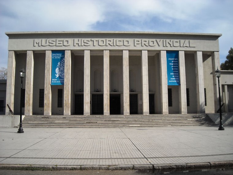 The Dr. Julio Marc Provincial Historical Museum is a museum in Rosario, Argentina. It comprises more than 30 rooms hosting collections of archaeological items, Spanish-American art, numismatics, pre-Columbian textile and silverwork crafts, and weapons, complemented by archives, a library, and collections of historical newspapers and maps. Dr. Julio Marc Provincial Historical Museum is situated 1 km north of Parque Infantil de Educación Vial.
Places in the Area
Nearby places include Rosario and Barrio Pichincha.
Rosario

Photo: ElGuruCesar, CC BY-SA 4.0.
Rosario is the third largest city in Argentina and the largest city in Santa Fe province, at the Paraná river. It is known for its rich architectural heritage and beautiful riverside scenery, and offers a vibrant cultural and night life.
Barrio Pichincha
Suburb
Pichincha is a barrio in the city of Rosario, province of Santa Fe, Argentina. It is located on the north-east part of the central area of the city, and its limits are Vera Mujica St, Cordoba St, Oroño Boulevard, and Del Valle Avenue. Barrio Pichincha is situated 3 km north of Parque Infantil de Educación Vial.
Barrio Echesortu
Suburb
Echesortu is a barrio in Rosario, Argentina. It is unofficially known by that name even though, from the administrative point of view, its name is Remedios Escalada de San Martín. Barrio Echesortu is situated 3½ km northwest of Parque Infantil de Educación Vial.
Parque Infantil de Educación Vial
- Category: recreation area
- Location: Rosario Department, Santa Fe, Pampas, Argentina, South America
- View on OpenStreetMap
Latitude
-32.96488° or 32° 57′ 54″ southLongitude
-60.65663° or 60° 39′ 24″ westOpen location code
47VX28PV+28OpenStreetMap ID
way 1095738570OpenStreetMap feature
leisure=playgroundOpenStreetMap attribute
wheelchair=limited
This page is based on OpenStreetMap, Wikidata, and Wikimedia Commons.
We’d love your help improving our open data sources. Thank you for contributing.
Satellite Map
Discover Parque Infantil de Educación Vial from above in high-definition satellite imagery.
Places with the Same Name
Discover other places named “Parque Infantil de Educación Vial”.
Notable Places Nearby
Highlights include Plazoleta Teniente Aviador Alfredo Vázquez and Plaza Pública de las Ciencias.
Nearby Places
Explore places such as 31 - Parque Independencia II and 7969.
Curious Playgrounds to Discover
Uncover intriguing playgrounds from every corner of the globe.
About Mapcarta. Data © OpenStreetMap contributors and available under the Open Database License". Text is available under the CC BY-SA 4.0 license, except for photos, directions, and the map. Photo: Wikimedia, CC0.