Blankenburg/H B3
Blankenburg/H B3 is a building in Blankenburg, Harz, Saxony-Anhalt. Blankenburg/H B3 is situated nearby to Fahrzeug- und Entwicklungswerk Blankenburg GmbH, as well as near the sports venue Sporthalle Regensteinschule.| Tap on a place to explore it |
Places of Interest Nearby
Highlights include Blankenburg station and Sportforum Blankenburg.
Blankenburg station
Railway station
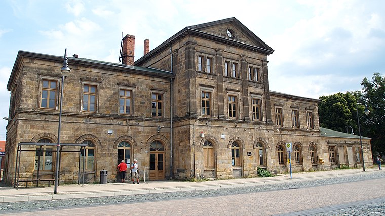
Photo: Angela Huster, CC0.
Blankenburg station is the most important station in Blankenburg in the Saxony-Anhalt district of Harz in central Germany. Blankenburg station is situated 1 km south of Blankenburg/H B3.
Sportforum Blankenburg
Sports venue

Photo: Wikimedia, CC BY-SA 3.0 de.
Sportforum Blankenburg is a sports venue, which is situated 490 metres southwest of Blankenburg/H B3.
Gymnasium Am Thie
School

Photo: Adkott2, CC BY-SA 4.0.
Gymnasium Am Thie is a school, which is situated 1 km south of Blankenburg/H B3.
Places in the Area
Nearby places include Langenstein and Westerhausen.
Langenstein
Village

Photo: B.Thomas95, CC BY-SA 4.0.
Langenstein is a village and a former municipality in the district of Harz, in Saxony-Anhalt, Germany. Since 1 January 2010, it is part of the town Halberstadt. The World War II concentration camp Langenstein-Zwieberge was located here. Langenstein is situated 6 km north of Blankenburg/H B3.
Westerhausen
Village

Photo: B.Thomas95, CC BY-SA 4.0.
Westerhausen is a village and a former municipality in the district of Harz, in Saxony-Anhalt, Germany. Since 1 September 2010, it is part of the town Thale. Westerhausen is situated 7 km east of Blankenburg/H B3.
Wendefurth
Hamlet

Photo: B.Thomas95, CC BY-SA 4.0.
Wendefurth is a hamlet in central Germany that, since 1 July 2009, has been part of the borough of Thale district of Harz. Previously it belonged to the municipality of Altenbrak which was incorporated into Thale. Wendefurth is situated 7 km south of Blankenburg/H B3.
Blankenburg/H B3
- Type: Building
- Category: historic site
- Location: Blankenburg, Harz, Saxony-Anhalt, Germany, Central Europe, Europe
- View on OpenStreetMap
Latitude
51.80289° or 51° 48′ 10″ northLongitude
10.95739° or 10° 57′ 27″ eastInception
1963Open location code
9F3GRX34+5XOpenStreetMap ID
way 110891552OpenStreetMap feature
building=yesOpenStreetMap feature
historic=yesOpenStreetMap feature
railway=signal_box
This page is based on OpenStreetMap, Wikidata, and Wikimedia Commons.
We’d love your help improving our open data sources. Thank you for contributing.
Satellite Map
Discover Blankenburg/H B3 from above in high-definition satellite imagery.
Notable Places Nearby
Highlights include Fahrzeug- und Entwicklungswerk Blankenburg GmbH and Sporthalle Regensteinschule.
Nearby Places
Explore places such as Cargo-Hütte and Ringlokschuppen.
Saxony-Anhalt: Must-Visit Destinations
Delve into Magdeburg, Halle, Wittenberg, and Quedlinburg.
Curious Buildings to Discover
Uncover intriguing buildings from every corner of the globe.
About Mapcarta. Data © OpenStreetMap contributors and available under the Open Database License". Text is available under the CC BY-SA 4.0 license, except for photos, directions, and the map. Photo: Mr. TI., CC BY 3.0.