Kundenparkplatz Johanniter-Unfall-Hilfe
Kundenparkplatz Johanniter-Unfall-Hilfe is a parking area in Wiesbaden, South Hesse, Hesse. Kundenparkplatz Johanniter-Unfall-Hilfe is situated nearby to the suburb Mainz-Amöneburg, as well as near the church Pfarrkirche Maria Immaculata.| Tap on a place to explore it |
- Opening hours: 24/7
- Type: Parking area
- Parking: surface
Places of Interest Nearby
Highlights include Wiesbaden Ost station and Gustav-Adolf-Gedächtniskirche (Mainz-Amöneburg).
Wiesbaden Ost station
Railway station

Photo: Jivee Blau, CC BY-SA 3.0.
Wiesbaden Ost station is situated on the Frankfurt–Wiesbaden line in the German state of Hesse. It was opened as part of the Taunus Railway, which was opened in 1839/40. Wiesbaden Ost station is situated 1 km north of Kundenparkplatz Johanniter-Unfall-Hilfe.
Gustav-Adolf-Gedächtniskirche (Mainz-Amöneburg)
Church
 Gustav-Adolf-Gedächtniskirche (Mainz-Amöneburg) is a church, which is situated 550 metres south of Kundenparkplatz Johanniter-Unfall-Hilfe.
Biebrich Palace

Photo: SBT, CC BY-SA 4.0.
Biebrich Palace is a Baroque residence in the borough of Biebrich in the city of Wiesbaden, Hesse, Germany. Built in 1702 by Prince Georg August Samuel of Nassau-Idstein, it served as the ducal residence for the independent Duchy of Nassau from 1816 until 1866. Biebrich Palace is situated 2 km west of Kundenparkplatz Johanniter-Unfall-Hilfe.
Places in the Area
Nearby places include Mainz-Amöneburg and Biebrich.
Mainz-Amöneburg
Suburb
Photo: Wikimedia, CC BY-SA 3.0 de.
Mainz-Amöneburg is a district administered by the city of Wiesbaden, Germany. Its population is 1,743. Mainz-Amöneburg was formerly a district of the city of Mainz, until the public administration by the city of Wiesbaden was decided on August 10, 1945.
Biebrich
Suburb
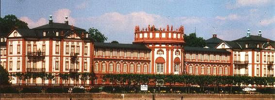
Photo: Wikimedia, Public domain.
Biebrich is a borough of the city of Wiesbaden, Hesse, Germany. With over 38,000 inhabitants, it is the most-populated of Wiesbaden's boroughs. It is located south of the city center on the Rhine River, opposite the Mainz borough of Mombach.
Mombach
Suburb
Mombach, with 13,927 inhabitants, is a borough in the northwest corner of Mainz, Germany. Mombach can be reached via Mainz-innenstadt or Bundesautobahn 643. Mombach is situated 3 km southwest of Kundenparkplatz Johanniter-Unfall-Hilfe.
Kundenparkplatz Johanniter-Unfall-Hilfe
- Category: transportation
- Location: Wiesbaden, South Hesse, Hesse, Germany, Central Europe, Europe
- View on OpenStreetMap
Latitude
50.03393° or 50° 2′ 2″ northLongitude
8.2603° or 8° 15′ 37″ eastOperator
Johanniter-Unfall-Hilfe e.V.Open location code
9F2C27M6+H4OpenStreetMap ID
way 1120713480OpenStreetMap feature
amenity=parkingOpenStreetMap attribute
parking=surface
This page is based on OpenStreetMap, Wikidata, and Wikimedia Commons.
We’d love your help improving our open data sources. Thank you for contributing.
Satellite Map
Discover Kundenparkplatz Johanniter-Unfall-Hilfe from above in high-definition satellite imagery.
Notable Places Nearby
Highlights include Pfarrkirche Maria Immaculata and Hambuschbrunnen.
Nearby Places
Explore places such as Rettungswache Süd and Johanniter-Unfall-Hilfe Geschäftsstelle Wiesbaden.
South Hesse: Must-Visit Destinations
Delve into Darmstadt, Bensheim, Lorsch, and Heppenheim.
Curious Parking Areas to Discover
Uncover intriguing parking areas from every corner of the globe.
About Mapcarta. Data © OpenStreetMap contributors and available under the Open Database License". Text is available under the CC BY-SA 4.0 license, except for photos, directions, and the map. Photo: Pedelecs, CC BY-SA 3.0.