大阪市立茨田東小学校
大阪市立茨田東小学校 is a school in Tsurumi-ku, Osaka, Osaka. 大阪市立茨田東小学校 is situated nearby to the park 茨田大宮南公園, as well as near Tsurumi Mattaomiya Post Office.| Tap on a place to explore it |
- Type: School
- Description: primary school
- Address: 61, 3丁目, 鶴見区, 大阪市, 大阪府 538-0031
Places of Interest Nearby
Highlights include Mitsui Outlet Park Osaka Tsurumi and Kōnoikeshinden Station.
Mitsui Outlet Park Osaka Tsurumi
Shopping center

Photo: Wikimedia, CC BY-SA 3.0.
Mitsui Outlet Park Osaka Tsurumi is a shopping center, which is situated 450 metres north of 大阪市立茨田東小学校.
Kōnoikeshinden Station
Railway station

Photo: Wikimedia, CC BY-SA 3.0.
Kōnoikeshinden Station is a passenger railway station in located in the city of Higashiōsaka, Osaka Prefecture, Japan, operated by West Japan Railway Company. Kōnoikeshinden Station is situated 1 km south of 大阪市立茨田東小学校.
Towa Pharmaceutical Ractab Dome
Sports venue
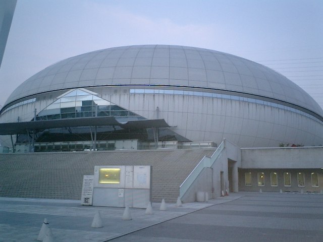
Photo: Wikimedia, CC BY-SA 3.0.
Towa Pharmaceutical Ractab Dome is an indoor sporting arena located in Kadoma city in the Osaka Prefecture of Japan. Construction was completed in early 1996. Towa Pharmaceutical Ractab Dome is situated 1 km north of 大阪市立茨田東小学校.
Places in the Area
Nearby places include Joto-ku and Asahi-ku.
Joto-ku
Suburb

Photo: 聖石大戦ぶぅぶぅ, CC BY-SA 4.0.
Jōtō-ku is one of the 24 wards of Osaka, Japan. "Jōtō" literally means "east of the castle", referring to Osaka Castle. It was separated from Higashinari and Asahi in 1943, and eastern Jōtō became Tsurumi in 1974. Joto-ku is situated 4½ km west of 大阪市立茨田東小学校.
Asahi-ku
Suburb
 Asahi is one of 24 wards of Osaka, Japan. It is located in the northeast of the city, near the satellite town of Moriguchi. It was split off from Higashinari in 1932. Asahi-ku is situated 5 km northwest of 大阪市立茨田東小学校.
Higashinari-ku
Suburb

Photo: Wikimedia, Public domain.
Higashinari-ku is one of 24 wards of Osaka, Japan. As of September 2010, it had a total population of 79,435. The ward is located east of Osaka City, and is bordered clockwise north by: Jōtō-ku ward, the core city of Higashiōsaka, and the wards of Ikuno-ku, Tennōji-ku, and Chūō-ku. Higashinari-ku is situated 6 km southwest of 大阪市立茨田東小学校.
大阪市立茨田東小学校
- Categories: elementary school in Japan and education
- Location: Tsurumi-ku, Osaka, Osaka, Kansai, Japan, East Asia, Asia
- View on OpenStreetMap
Latitude
34.70838° or 34° 42′ 30″ northLongitude
135.59472° or 135° 35′ 41″ eastOpen location code
8Q6QPH5V+9VOpenStreetMap ID
way 1124745558OpenStreetMap feature
amenity=schoolWikidata ID
Q11440701
This page is based on OpenStreetMap, Wikidata, and Wikimedia Commons.
We’d love your help improving our open data sources. Thank you for contributing.
Satellite Map
Discover 大阪市立茨田東小学校 from above in high-definition satellite imagery.
In Other Languages
“大阪市立茨田東小学校” goes by many names.
- Japanese: “大阪市立茨田東小学校”
- Japanese: “茨田東小学校”
Notable Places Nearby
Highlights include 茨田大宮南公園 and Tsurumi Mattaomiya Post Office.
Nearby Places
Explore places such as 前川モータープール and 7-Eleven.
Osaka: Must-Visit Destinations
Delve into Toyonaka, Osaka castle, Bay Area, and Universal Studios Japan.
Curious Places to Discover
Uncover intriguing places from every corner of the globe.
About Mapcarta. Data © OpenStreetMap contributors and available under the Open Database License". Text is available under the CC BY-SA 4.0 license, except for photos, directions, and the map. Photo: Kaiza96, CC BY-SA 3.0.