The Church of Jesus Christ - Cutlerites
The Church of Jesus Christ - Cutlerites is a church in Blue Township, Jackson County, Missouri which is located on South Cottage Street. The Church of Jesus Christ - Cutlerites is situated nearby to Restoration Church of Jesus Christ of Latter Day Saints, as well as near the railway station Amtrak Independence Station.| Tap on a place to explore it |
Places of Interest Nearby
Highlights include Independence station and Auditorium.
Independence station
Railway station
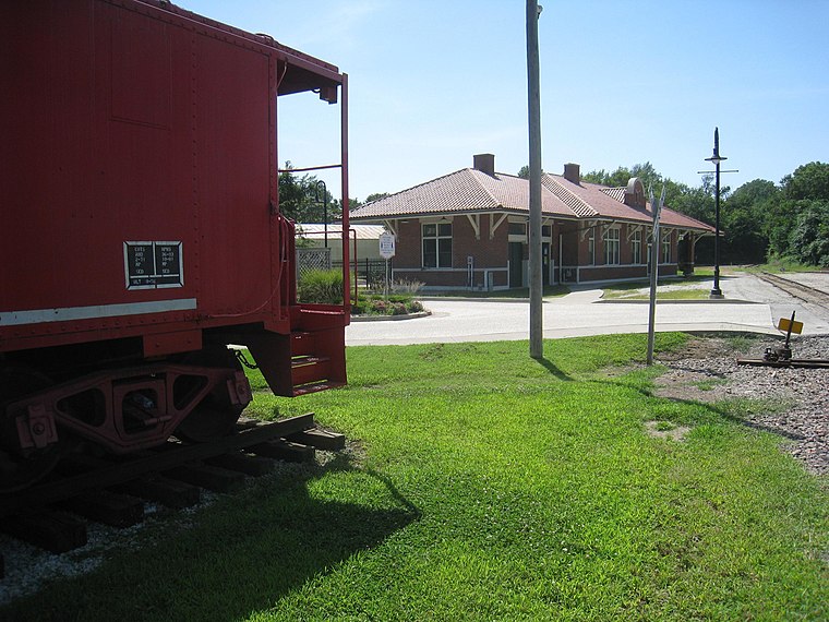
Photo: EGDJ, Public domain.
Independence station, also known as Missouri Pacific Depot, is an Amtrak train station in Independence, Missouri, United States. The station was originally built in 1913 by the Missouri Pacific Railroad, and is also known as the "Truman Depot", because it was the final stop in Harry S. Independence station is situated 1,500 feet northwest of The Church of Jesus Christ - Cutlerites.
Auditorium
Church
The Auditorium is a house of worship and office building located on the greater Temple Lot in Independence, Missouri. The Auditorium is part of the headquarters complex of Community of Christ which also includes the Independence Temple. Auditorium is situated 2,200 feet north of The Church of Jesus Christ - Cutlerites.
Temple Lot
Park
 The Temple Lot is a parcel of land located in Independence, Missouri, which is an important site in the history of the Latter Day Saint movement as the first location dedicated to the construction of a temple. Temple Lot is situated 2,600 feet north of The Church of Jesus Christ - Cutlerites.
Places in the Area
Nearby places include Independence and Leeds.
Independence

Photo: Wikimedia, Public domain.
Independence, known as the Queen City of the Trails, is a city in western Missouri just east of Kansas City with a population of approximately 110,000.
Leeds
Hamlet
Leeds is a neighborhood of Kansas City, Missouri, United States. A post office called Leeds was established in 1890, and remained in operation until 1929. Leeds is situated 5 miles southwest of The Church of Jesus Christ - Cutlerites.
Raytown
Town

Photo: Ichabod, CC BY-SA 3.0.
Raytown is a city in Jackson County, Missouri, United States, and is a suburb of Kansas City. The population was at 30,012 in 2020 census. The current mayor of Raytown is Michael McDonough. It is part of the Kansas City metropolitan area. Raytown is situated 6 miles south of The Church of Jesus Christ - Cutlerites.
The Church of Jesus Christ - Cutlerites
- Type: Church
- Address: 807 South Cottage Street, Independence, MO 64050
- Categories: building, place of worship, and religion
- Location: Blue Township, Jackson County, Missouri, Midwest, United States, North America
- View on OpenStreetMap
Latitude
39.08381° or 39° 5′ 2″ northLongitude
-94.42635° or 94° 25′ 35″ westOpen location code
86F73HMF+GFOpenStreetMap ID
way 1126418580OpenStreetMap feature
amenity=place_of_worshipOpenStreetMap feature
building=church
This page is based on OpenStreetMap, Wikidata, and Wikimedia Commons.
We’d love your help improving our open data sources. Thank you for contributing.
Satellite Map
Discover The Church of Jesus Christ - Cutlerites from above in high-definition satellite imagery.
Notable Places Nearby
Highlights include Restoration Church of Jesus Christ of Latter Day Saints and Amtrak Independence Station.
Nearby Places
Explore places such as Allis Chalmers Industrial Park and Independence.
Missouri: Must-Visit Destinations
Delve into St. Louis, Jefferson City, Kansas City, and Springfield.
Curious Churches to Discover
Uncover intriguing churches from every corner of the globe.
About Mapcarta. Data © OpenStreetMap contributors and available under the Open Database License". Text is available under the CC BY-SA 4.0 license, except for photos, directions, and the map. Photo: Wikimedia, Public domain.