Kugelstoßring
Kugelstoßring is an athletics track in Sigmaringen, Tübingen Region, Baden-Württemberg. Kugelstoßring is situated nearby to the pitch Roter Platz, as well as near the garden Schulgarten.| Tap on a place to explore it |
Places of Interest Nearby
Highlights include Liebfrauenschule Sigmaringen and Sigmaringen Castle.
Liebfrauenschule Sigmaringen
School

Photo: Louis Bafrance, CC BY-SA 4.0.
Liebfrauenschule Sigmaringen is a school, which is situated 140 metres northeast of Kugelstoßring.
Sigmaringen Castle
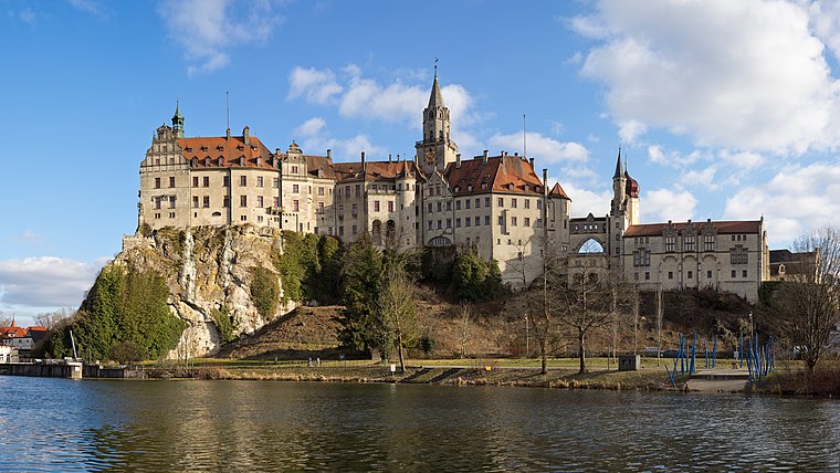
Photo: Milseburg, CC BY-SA 4.0.
Sigmaringen Castle was the princely castle and seat of government for the Princes of Hohenzollern-Sigmaringen. Situated in the Swabian Alb region of Baden-Württemberg, Germany, this castle dominates the skyline of the town of Sigmaringen. Sigmaringen Castle is situated 1 km west of Kugelstoßring.
Kloster Hedingen
Monastery

Photo: Ssch, CC BY-SA 3.0.
Kloster Hedingen is a monastery, which is situated 590 metres southwest of Kugelstoßring.
Places in the Area
Nearby places include Sigmaringendorf and Inzigkofen.
Sigmaringendorf
Village
Photo: Louis Bafrance, CC BY-SA 3.0.
Sigmaringendorf is a small town in the district of Sigmaringen in Baden-Württemberg in Germany. In Sigmaringendorf the small river Lauchert flows into the Danube. There is an open-air-theatre in Sigmaringendorf, it's called Waldbühne Sigmaringendorf. Sigmaringendorf is situated 3 km southeast of Kugelstoßring.
Inzigkofen
Village

Photo: Simisa, CC BY-SA 3.0.
Inzigkofen is a municipality in the district of Sigmaringen in Baden-Württemberg in Germany. Historically, it is part of the Swabian north Alpine foreland basin. Inzigkofen is situated 4 km west of Kugelstoßring.
Bingen
Village
Bingen is a municipality in the district of Sigmaringen in Baden-Württemberg in Germany. Bingen is situated 4½ km northeast of Kugelstoßring.
Kugelstoßring
- Type: Athletics track
- Categories: athletics, recreation area, and sports location
- Location: Sigmaringen, Sigmaringen, Tübingen Region, Bodensee Region, Baden-Württemberg, Germany, Central Europe, Europe
- View on OpenStreetMap
Latitude
48.08447° or 48° 5′ 4″ northLongitude
9.23056° or 9° 13′ 50″ eastOpen location code
8FWF36MJ+Q6OpenStreetMap ID
way 1138333820OpenStreetMap feature
leisure=trackOpenStreetMap feature
sport=athletics
This page is based on OpenStreetMap, Wikidata, and Wikimedia Commons.
We’d love your help improving our open data sources. Thank you for contributing.
Satellite Map
Discover Kugelstoßring from above in high-definition satellite imagery.
Notable Places Nearby
Highlights include Kugelstoßring and Roter Platz.
Nearby Places
Explore places such as Bau D and Bau C.
Bodensee Region: Must-Visit Destinations
Delve into Konstanz, Friedrichshafen, Ravensburg, and Überlingen.
Curious Athletics Tracks to Discover
Uncover intriguing athletics tracks from every corner of the globe.
About Mapcarta. Data © OpenStreetMap contributors and available under the Open Database License". Text is available under the CC BY-SA 4.0 license, except for photos, directions, and the map. Photo: Berthold Werner, CC BY-SA 4.0.