Grenades
Grenades is a building in Saint-Mandrier-sur-Mer, Arrondissement of Toulon, Provence-Alpes-Côte d’Azur. Grenades is situated nearby to the dive center Evasion Plongée, as well as near the post office Bureau de Poste de Saint Mandrier Sur Mer.| Tap on a place to explore it |
Places of Interest Nearby
Highlights include Église Saint-Mandrier de Saint-Mandrier-sur-Mer and Cap Cépet Lighthouse.
Église Saint-Mandrier de Saint-Mandrier-sur-Mer
Church

Photo: BLUMJ, CC BY-SA 3.0.
Église Saint-Mandrier de Saint-Mandrier-sur-Mer is a church, which is situated 300 metres west of Grenades.
Cap Cépet Lighthouse
Lighthouse
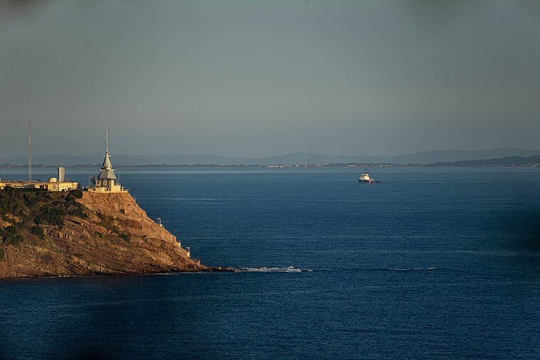
Photo: Adltbc92, CC BY-SA 3.0.
Cap Cépet Lighthouse is situated 1½ km southeast of Grenades.
Tour Royale
Fort

Photo: Wikimedia, CC BY-SA 2.0 fr.
The Tour Royale is a fort built in the 16th century to protect the entrance of the Petit Rade, the naval port of Toulon. It was the first fortification of the harbor, built 22 years after Provence became a part of France. Tour Royale is situated 3 km north of Grenades.
Places in the Area
Nearby places include Le Mourillon and Cap Brun.
Le Mourillon
Suburb

Photo: Maisrimer, Public domain.
Le Mourillon is a neighbourhood to the east of the French city of Toulon, near the entrance to the Rade or roadstead. It was once a fishing village, and then became the home of many of the officers of the French fleet and to part of the naval dockyard. Le Mourillon is situated 3½ km north of Grenades.
Cap Brun
Suburb

Photo: Adltbc92, CC BY-SA 3.0.
Cap Brun is a suburb, which is situated 5 km northeast of Grenades.
Basse Ville
Suburb

Photo: SiefkinDR, Public domain.
Basse Ville is a suburb, which is situated 5 km north of Grenades.
Grenades
Latitude
43.07615° or 43° 4′ 34″ northLongitude
5.93161° or 5° 55′ 54″ eastOpen location code
8FM73WGJ+FJOpenStreetMap ID
way 1163111423OpenStreetMap feature
building=yes
This page is based on OpenStreetMap, Wikidata, and Wikimedia Commons.
We’d love your help improving our open data sources. Thank you for contributing.
Satellite Map
Discover Grenades from above in high-definition satellite imagery.
Notable Places Nearby
Highlights include Evasion Plongée and Bureau de Poste de Saint Mandrier Sur Mer.
Nearby Places
Explore places such as Santolines and Chênes verts.
Var: Must-Visit Destinations
Delve into Toulon, Saint-Tropez, Hyères, and Fréjus.
Curious Buildings to Discover
Uncover intriguing buildings from every corner of the globe.
About Mapcarta. Data © OpenStreetMap contributors and available under the Open Database License". Text is available under the CC BY-SA 4.0 license, except for photos, directions, and the map. Photo: Tobi 87, CC BY-SA 3.0.