Höhenwirt
Höhenwirt is a restaurant in Keutschach am See, Klagenfurt-Land District, Carinthia which is located on Höhe. Höhenwirt is situated nearby to Waldseilpark Pyramidenkogel, as well as near the peak Paulich Kogel.| Tap on a place to explore it |
Places of Interest Nearby
Highlights include Pyramidenkogel and Pyramidenkogel Tower.
Pyramidenkogel
Peak

Photo: Johann Jaritz, CC BY-SA 3.0 at.
Pyramidenkogel is an 851-metre-high mountain in Carinthia, Austria. It is located to the south of the Wörthersee and near the town of Maria Wörth, in an area that is a boundary between speakers of German and Slovenian.
Pyramidenkogel Tower

Photo: Bwag, CC BY-SA 4.0.
Pyramidenkogel Tower is situated 1 km northeast of Höhenwirt.
Church of Saint Ulrich and Martin
Church

Photo: Wikimedia, CC BY 3.0 at.
Church of Saint Ulrich and Martin is situated 1½ km west of Höhenwirt.
Places in the Area
Nearby places include Schiefling am Wörthersee and Pörtschach.
Schiefling am Wörthersee
Village
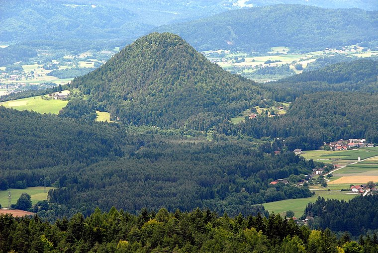
Photo: Johann Jaritz, CC BY-SA 3.0 at.
Schiefling am Wörthersee is a market town in the district of Klagenfurt-Land in the Austrian state of Carinthia. Schiefling am Wörthersee is situated 3½ km west of Höhenwirt.
Pörtschach

Photo: Johann Jaritz, CC BY-SA 3.0 at.
Pörtschach am Wörthersee is a municipality in the district of Klagenfurt-Land in Carinthia, Austria. It is an established summer resort and lakeside town on Wörthersee.
Krumpendorf am Wörthersee
Village

Photo: Wikimedia, Public domain.
Krumpendorf am Wörthersee is a municipality in Klagenfurt-Land District, in Carinthia, Austria. It is situated on the Wörthersee. Krumpendorf am Wörthersee is situated 6 km northeast of Höhenwirt.
Höhenwirt
- Type: Restaurant
- Address: Höhe 4, Keutschach am See, 9074
- Categories: building and food
- Location: Keutschach am See, Klagenfurt-Land District, Carinthia, Austria, Central Europe, Europe
- View on OpenStreetMap
Latitude
46.60058° or 46° 36′ 2″ northLongitude
14.13891° or 14° 8′ 20″ eastOpen location code
8FRPJ42Q+6HOpenStreetMap ID
way 116382896OpenStreetMap feature
amenity=restaurantOpenStreetMap feature
building=yes
This page is based on OpenStreetMap, Wikidata, and Wikimedia Commons.
We’d love your help improving our open data sources. Thank you for contributing.
Satellite Map
Discover Höhenwirt from above in high-definition satellite imagery.
Notable Places Nearby
Highlights include Waldseilpark Pyramidenkogel and Paulich Kogel.
Nearby Places
Explore places such as St.Margarethen b.Keutschach Abzw Höhenwirt and St.Margarethen b.Keutschach Abzw Höhenwirt.
Carinthia: Must-Visit Destinations
Delve into Klagenfurt, Villach, Wörthersee, and Spittal an der Drau.
Curious Restaurants to Discover
Uncover intriguing restaurants from every corner of the globe.
About Mapcarta. Data © OpenStreetMap contributors and available under the Open Database License". Text is available under the CC BY-SA 4.0 license, except for photos, directions, and the map. Photo: Wikimedia, CC BY-SA 3.0.