TSV Unterlauter
TSV Unterlauter is a sports venue in Lautertal, Landkreis Coburg, Bavaria. TSV Unterlauter is situated nearby to the peak Weinberg, as well as near Holy Trinity church (Unterlauter).| Tap on a place to explore it |
Places of Interest Nearby
Highlights include Holy Trinity church (Unterlauter) and Coburg Fortress.
Holy Trinity church (Unterlauter)
Church

Photo: Wikimedia, CC BY-SA 3.0 de.
Holy Trinity church (Unterlauter) is situated 410 metres east of TSV Unterlauter.
Coburg Fortress
Castle
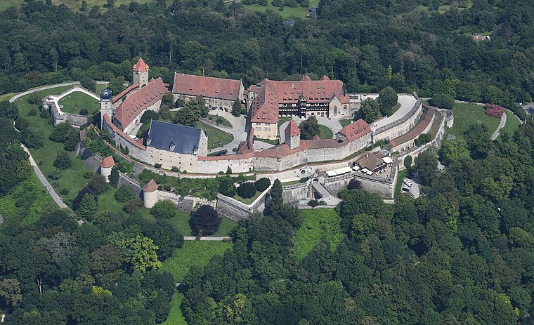
Photo: Carsten Steger, CC BY-SA 4.0.
The Veste Coburg is one of the best-preserved medieval fortresses of Germany. It is situated on a hill above the town of Coburg, in the Upper Franconia region of Bavaria. Coburg Fortress is situated 4 km south of TSV Unterlauter.
Kirche
Church

Photo: Wikimedia, CC BY-SA 3.0 de.
Kirche is a church, which is situated 1½ km northeast of TSV Unterlauter.
Places in the Area
Nearby places include Unterlauter and Bertelsdorf.


TSV Unterlauter
- Type: Sports venue
- Categories: recreation area and sports location
- Location: Lautertal, Landkreis Coburg, Upper Franconia, Franconia, Bavaria, Germany, Central Europe, Europe
- View on OpenStreetMap
Latitude
50.29746° or 50° 17′ 51″ northLongitude
10.97206° or 10° 58′ 19″ eastOpen location code
9F2G7XWC+XROpenStreetMap ID
way 1186560147OpenStreetMap feature
leisure=sports_centre
This page is based on OpenStreetMap, Wikidata, and Wikimedia Commons.
We’d love your help improving our open data sources. Thank you for contributing.
Satellite Map
Discover TSV Unterlauter from above in high-definition satellite imagery.
Notable Places Nearby
Highlights include Weinberg and Kirchturm.
Nearby Places
Explore places such as Sportheimgaststätte TSV Unterlauter and Discount Retouren.
Upper Franconia: Must-Visit Destinations
Delve into Bamberg, Bayreuth, Coburg, and Hof.
Curious Sports Venues to Discover
Uncover intriguing sports venues from every corner of the globe.
About Mapcarta. Data © OpenStreetMap contributors and available under the Open Database License". Text is available under the CC BY-SA 4.0 license, except for photos, directions, and the map. Photo: Wikimedia, CC0.