Cabourg Avenue Michel d’Ornano
Cabourg Avenue Michel d’Ornano is a motorhome stopover in Cabourg, Arrondissement of Lisieux, Normandy. Cabourg Avenue Michel d’Ornano is situated nearby to the community center Sall’in, as well as near the sports venue Hippodrome de Cabourg.| Tap on a place to explore it |
Places of Interest Nearby
Highlights include Église Saint-Michel de Cabourg and Dives-Cabourg station.
Église Saint-Michel de Cabourg
Church

Photo: Chatsam, CC BY-SA 4.0.
Église Saint-Michel de Cabourg is a church, which is situated 480 metres north of Cabourg Avenue Michel d’Ornano.
Dives-Cabourg station
Railway station
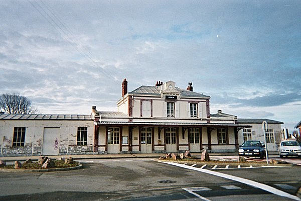
Photo: Captain Scarlet, CC BY 2.5.
Dives-Cabourg is the railway station for the towns of Dives-sur-Mer and Cabourg. The station is built in Ouest architecture and is a terminus for the Côte Fleurie branchline to Trouville-Deauville. Dives-Cabourg station is situated 1 km northeast of Cabourg Avenue Michel d’Ornano.
Gare de Dives-sur-Mer-Port-Guillaume
Railway station

Photo: Reinhardhauke, CC BY-SA 3.0.
Gare de Dives-sur-Mer-Port-Guillaume is a railway station, which is situated 1½ km northeast of Cabourg Avenue Michel d’Ornano.
Places in the Area
Nearby places include Dives-sur-Mer and Périers-en-Auge.
Dives-sur-Mer
Town

Photo: Ikmo-ned, CC BY-SA 3.0.
Dives-sur-Mer is a commune in the Calvados department in Normandy in northwestern France.
Périers-en-Auge
Village

Photo: Pymouss, CC BY-SA 3.0.
Périers-en-Auge is a commune in the Calvados department in the Normandy region in northwestern France. Périers-en-Auge is situated 4 km southeast of Cabourg Avenue Michel d’Ornano.
Grangues
Village

Photo: Ikmo-ned, CC BY-SA 3.0.
Grangues is a commune in the Calvados department and Normandy region of north-western France. Grangues is situated 5 km east of Cabourg Avenue Michel d’Ornano.
Cabourg Avenue Michel d’Ornano
- Type: Motorhome stopover
- Categories: tourism and transportation
- Location: Cabourg, Arrondissement of Lisieux, Calvados, Normandy, France, Europe
- View on OpenStreetMap
Latitude
49.28232° or 49° 16′ 56″ northLongitude
-0.11925° or 0° 7′ 9″ westOpen location code
8CXX7VJJ+W8OpenStreetMap ID
way 1190646972OpenStreetMap feature
tourism=caravan_site
This page is based on OpenStreetMap, Wikidata, and Wikimedia Commons.
We’d love your help improving our open data sources. Thank you for contributing.
Satellite Map
Discover Cabourg Avenue Michel d’Ornano from above in high-definition satellite imagery.
Notable Places Nearby
Highlights include Sall’in and Hippodrome de Cabourg.
Nearby Places
Explore places such as Secours Catholique and Arc-en-ciel.
Normandy: Must-Visit Destinations
Delve into Orne, Rouen, Seine-Maritime, and Le Havre.
Curious Motorhome Stopovers to Discover
Uncover intriguing motorhome stopovers from every corner of the globe.
About Mapcarta. Data © OpenStreetMap contributors and available under the Open Database License". Text is available under the CC BY-SA 4.0 license, except for photos, directions, and the map. Photo: Inkey, CC BY-SA 3.0.