Coleman10
Coleman10 is a building in Frankfurt, South Hesse, Hesse which is located on Bessie-Coleman-Straße. Coleman10 is situated nearby to the university HOLM House of Logistics and Mobility, as well as near the square Eco-Kart.| Tap on a place to explore it |
Places of Interest Nearby
Highlights include Gateway Gardens station and Steigenberger Airport Hotel Frankfurt.
Gateway Gardens station
Railway stop

Photo: JeLuF, CC BY-SA 4.0.
Gateway Gardens is an underground railway station 1 kilometre east of Frankfurt Airport in Germany. It is between Frankfurt Stadion station and Frankfurt Airport regional station on lines S8 and S9 of the Rhine-Main S-Bahn commuter network. Gateway Gardens station is situated 200 metres east of Coleman10.
Steigenberger Airport Hotel Frankfurt
Hotel

Photo: qwesy qwesy, CC BY 3.0.
Steigenberger Airport Hotel Frankfurt is situated 240 metres northwest of Coleman10.
Frankfurt Airport long-distance station
Railway station
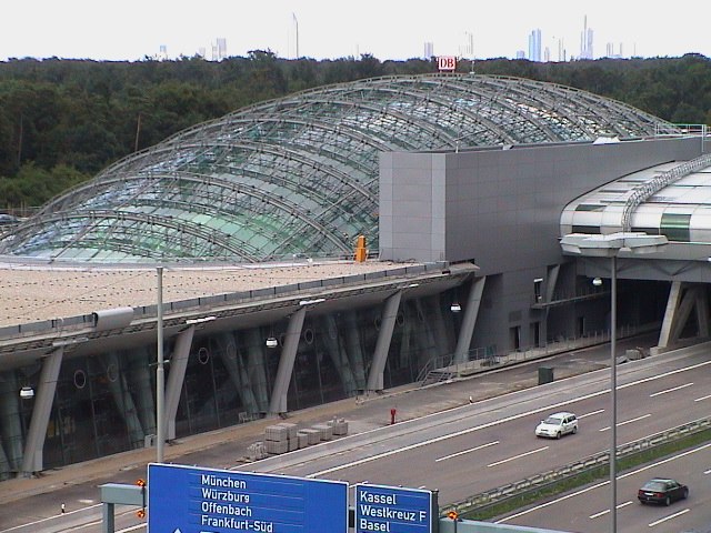
Photo: Wikimedia, CC BY-SA 3.0.
Frankfurt am Main Airport long-distance station is a railway station at Frankfurt Airport in Frankfurt, Germany. It is served by long-distance trains, mostly ICE services running on the Cologne–Frankfurt high-speed rail line. Frankfurt Airport long-distance station is situated 1½ km west of Coleman10.
Places in the Area
Nearby places include Kelsterbacher Terrasse and Zeppelinheim.
Kelsterbacher Terrasse
Locality

Photo: Frank Behnsen, CC BY-SA 3.0.
Kelsterbacher Terrasse is a locality, which is situated 2½ km northwest of Coleman10.
Zeppelinheim
Village

Photo: Andy Dingley, Public domain.
Zeppelinheim is a village, which is situated 3 km southeast of Coleman10.
Schwedenschanze Kelsterbach
Locality

Photo: Frank Winkelmann, CC BY 3.0.
Schwedenschanze Kelsterbach is a locality, which is situated 4 km west of Coleman10.
Coleman10
- Type: Building
- Address: Bessie-Coleman-Straße 10, Frankfurt am Main, 60549
- Location: Frankfurt, South Hesse, Hesse, Germany, Central Europe, Europe
- View on OpenStreetMap
Latitude
50.05705° or 50° 3′ 25″ northLongitude
8.59204° or 8° 35′ 31″ eastOpen location code
9F2C3H4R+RROpenStreetMap ID
way 1192584549OpenStreetMap feature
building=construction
This page is based on OpenStreetMap, Wikidata, and Wikimedia Commons.
We’d love your help improving our open data sources. Thank you for contributing.
Satellite Map
Discover Coleman10 from above in high-definition satellite imagery.
Notable Places Nearby
Highlights include HOLM House of Logistics and Mobility and Eco-Kart.
Nearby Places
Explore places such as Smartments Business Apartments and Einheitsmännchen.
South Hesse: Must-Visit Destinations
Delve into Darmstadt, Bensheim, Lorsch, and Heppenheim.
Curious Buildings to Discover
Uncover intriguing buildings from every corner of the globe.
About Mapcarta. Data © OpenStreetMap contributors and available under the Open Database License". Text is available under the CC BY-SA 4.0 license, except for photos, directions, and the map. Photo: Mylius, GFDL.