Strandhalle Ahrenshoop
Strandhalle Ahrenshoop is an event venue in Ahrenshoop, Landkreis Vorpommern-Rügen, Mecklenburg-Western Pomerania. Strandhalle Ahrenshoop is situated nearby to the art gallery Alte Schule, as well as near the tourism office Kurverwaltung.| Tap on a place to explore it |
Places of Interest Nearby
Highlights include Bunte Stube and Schifferkirche Ahrenshoop.
Bunte Stube
Bookstore

Photo: Derbrauni, CC BY-SA 4.0.
Bunte Stube is a bookstore, which is situated 110 metres northeast of Strandhalle Ahrenshoop.
Schifferkirche Ahrenshoop
Church

Photo: Schiwago, CC BY-SA 3.0.
Schifferkirche Ahrenshoop is a church, which is situated 450 metres east of Strandhalle Ahrenshoop.
Kunstmuseum Ahrenshoop
Museum
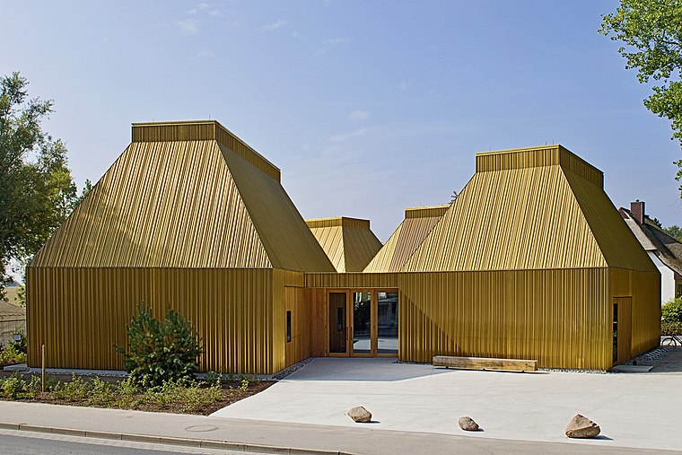
Photo: Wikimedia, CC BY-SA 3.0.
Kunstmuseum Ahrenshoop is situated 700 metres south of Strandhalle Ahrenshoop.
Places in the Area
Nearby places include Althagen and Niehagen.
Althagen
Village
The village of Althagen on the peninsula of Fischland-Darß-Zingst in the German state of Mecklenburg-Vorpommern has been a part of the municipality of Ahrenshoop since 1950.
Niehagen
Village
Niehagen is a village in the municipality of Ahrenshoop on the Fischland-Darß-Zingst peninsula in the German state of Mecklenburg-West Pomerania. On the steep coast near Althagen/Niehagen lies the Bakelberg knoll.
Wustrow
Village

Photo: Darkone, CC BY-SA 2.0.
Wustrow is a municipality in the Vorpommern-Rügen district, in Mecklenburg-Vorpommern, Germany. The first industrial wind turbine, a Vestas V25-200 kW wind turbine with a nacelle height of 28.5 metres and a rotor diameter of 25 metres, is situated there. Wustrow is situated 4 km southwest of Strandhalle Ahrenshoop.
Strandhalle Ahrenshoop
- Type: Event venue
- Category: building
- Location: Ahrenshoop, Landkreis Vorpommern-Rügen, Mecklenburg-Western Pomerania, Germany, Central Europe, Europe
- View on OpenStreetMap
Latitude
54.38116° or 54° 22′ 52″ northLongitude
12.4187° or 12° 25′ 7″ eastOpen location code
9F6J9CJ9+FFOpenStreetMap ID
way 1203851566OpenStreetMap feature
amenity=events_venueOpenStreetMap feature
building=yes
This page is based on OpenStreetMap, Wikidata, and Wikimedia Commons.
We’d love your help improving our open data sources. Thank you for contributing.
Satellite Map
Discover Strandhalle Ahrenshoop from above in high-definition satellite imagery.
Notable Places Nearby
Highlights include Alte Schule and Kurverwaltung.
Nearby Places
Explore places such as Thuro-Balzer-Haus and Carl-Rahtjen-Haus.
Mecklenburg-Western Pomerania: Must-Visit Destinations
Delve into Schwerin, Rostock, Wismar, and Stralsund.
Curious Event Venues to Discover
Uncover intriguing event venues from every corner of the globe.
About Mapcarta. Data © OpenStreetMap contributors and available under the Open Database License". Text is available under the CC BY-SA 4.0 license, except for photos, directions, and the map. Photo: Schiwago, CC BY 2.5.