WOW Chicken
WOW Chicken is a restaurant in Calgary, Calgary Region, Alberta. WOW Chicken is situated nearby to the government office Calgary Registry Services, as well as near the health club Rumble Boxing Studio.| Tap on a place to explore it |
Places of Interest Nearby
Highlights include Dalhousie station and Crowfoot station.
Dalhousie station
Railway station
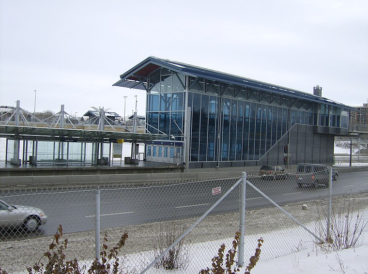
Photo: Thivierr, CC BY-SA 3.0.
Dalhousie station is a CTrain light rail station in Dalhousie, Calgary, Alberta, Canada. It opened on December 15, 2003, as part of a 2.8 km extension of the Northwest line, and was the terminal station of the NW line until June 14, 2009. Dalhousie station is situated 4 km south of WOW Chicken.
Crowfoot station
Railway station

Photo: Greenwood714, CC BY-SA 3.0.
Crowfoot station is a CTrain light rail station in Calgary, Alberta, Canada adjacent to Scenic Acres and Arbour Lake. It opened on June 15, 2009 as part of a 4 km extension, of Route 201 and was the line's northern terminus until August 23, 2014. Crowfoot station is situated 4 km southwest of WOW Chicken.
Robert Thirsk High School
School
Robert Thirsk High School is a public senior high school in Calgary, Alberta, Canada. It derives its name from Robert Thirsk, a Canadian engineer and physician, and a former Canadian Space Agency astronaut. Robert Thirsk High School is situated 2½ km west of WOW Chicken.
Places in the Area
Nearby places include Hamptons and Citadel.
Hamptons
Suburb
Hamptons is a residential neighbourhood in the northwest quadrant of Calgary, Alberta. It is located close to the northern edge of the city, and is bounded to the north by Stoney Trail, to the east by Shaganappi Trail, to the south by Country Hills Boulevard, and to the west by Sarcee Trail.
Citadel
Suburb
Citadel is a community in Northwest Calgary, Alberta. It is bordered by Stoney Trail on the north and west, Country Hills Blvd on the south, and Sarcee Trail on the east.
Edgemont
Suburb
Edgemont is a residential neighbourhood in northwest Calgary, Alberta, Canada, and is located north of the community of Dalhousie. It is also bounded by John Laurie Boulevard to the south, Sarcee Trail to the west, Country Hills Boulevard to the north, and Shaganappi Trail to the east.
WOW Chicken
- Type: Restaurant
- Cuisine: Korean
- Categories: building and food
- Location: Calgary, Calgary Region, Alberta, Prairies, Canada, North America
- View on OpenStreetMap
Latitude
51.13846° or 51° 8′ 19″ northLongitude
-114.15829° or 114° 9′ 30″ westOpen location code
95374RQR+9MOpenStreetMap ID
way 1257645726OpenStreetMap feature
amenity=restaurantOpenStreetMap feature
building=yesOpenStreetMap attribute
cuisine=korean
This page is based on OpenStreetMap, Wikidata, and Wikimedia Commons.
We’d love your help improving our open data sources. Thank you for contributing.
Satellite Map
Discover WOW Chicken from above in high-definition satellite imagery.
Places with the Same Name
Discover other places named “WOW Chicken”.
Notable Places Nearby
Highlights include Calgary Registry Services and Rumble Boxing Studio.
Nearby Places
Explore places such as AROMA Dim Sum and Dairy Queen.
Calgary: Must-Visit Destinations
Delve into City Centre, Northwest Calgary, Southwest Calgary, and Southeast Calgary.
Curious Restaurants to Discover
Uncover intriguing restaurants from every corner of the globe.
About Mapcarta. Data © OpenStreetMap contributors and available under the Open Database License". Text is available under the CC BY-SA 4.0 license, except for photos, directions, and the map. Photo: Wikimedia, CC0.