Interspar
Interspar is a supermarket in Primorje-Gorski Kotar County, Croatia. Interspar is situated nearby to the railway stop Krnjevo, as well as near the suburb Sveti Nikola, Rijeka.| Tap on a place to explore it |
- Opening hours: 7:00 AM—9:00 PM
- Type: Supermarket
- Wheelchair access: yes
Places of Interest Nearby
Highlights include Stadion Rujevica and Stadion Kantrida.
Stadion Rujevica
Stadium

Photo: Драган Јањушевић, CC BY-SA 4.0.
Stadion Rujevica, officially known as Stadion HNK Rijeka, is a stadium in the city of Rijeka, Croatia. The stadium is commonly referred to as Rujevica after its location. Stadion Rujevica is situated 1 km north of Interspar.
Stadion Kantrida
Stadium
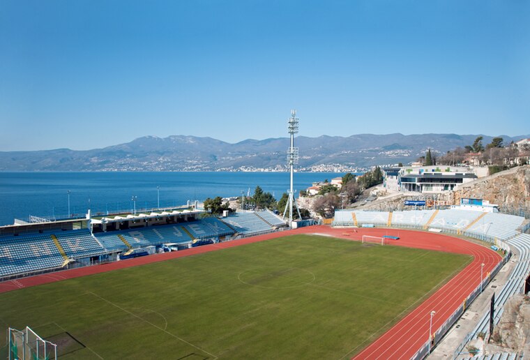
Photo: Roberta F., CC BY-SA 3.0.
Kantrida Stadium is a football stadium in the Croatian city of Rijeka. It is named after the Kantrida neighbourhood in which it is located, in the western part of the city. Stadion Kantrida is situated 1½ km west of Interspar.
Rijeka Mosque
Mosque

Photo: Dans, CC BY-SA 4.0.
Rijeka Mosque is a mosque in Rijeka, Croatia built between 2009 and 2013. The mosque is a part of the Islamic Cultural Center which was built on the 10,816 square meters plot and which itself covers 5,291 square meters. Rijeka Mosque is situated 1 km north of Interspar.
Places in the Area
Nearby places include Sveti Nikola, Rijeka and Turnić, Rijeka.
Sveti Nikola, Rijeka
Suburb

Photo: Zoran Kurelić Rabko, CC BY-SA 3.0.
Sveti Nikola, Rijeka is a suburb.


Interspar
- Categories: building, shop, and food
- Location: Primorje-Gorski Kotar County, Croatia, Balkans, Europe
- View on OpenStreetMap
Latitude
45.33827° or 45° 20′ 18″ northLongitude
14.40103° or 14° 24′ 4″ eastBrand
SPAROpen location code
8FQP8CQ2+8COpenStreetMap ID
way 1259174963OpenStreetMap feature
building=yesOpenStreetMap feature
shop=supermarketOpenStreetMap attribute
wheelchair=yes
This page is based on OpenStreetMap, Wikidata, and Wikimedia Commons.
We’d love your help improving our open data sources. Thank you for contributing.
Satellite Map
Discover Interspar from above in high-definition satellite imagery.
Places with the Same Name
Discover other places named “Interspar”.
Notable Places Nearby
Highlights include Krnjevo and Mjesni odbor Sveti Nikola.
Nearby Places
Explore places such as Tutto Bene and Krnjevo Liburnijska.
Croatia: Must-Visit Destinations
Delve into Zagreb, Dubrovnik, Split, and Rijeka.
Curious Supermarkets to Discover
Uncover intriguing supermarkets from every corner of the globe.
About Mapcarta. Data © OpenStreetMap contributors and available under the Open Database License". Text is available under the CC BY-SA 4.0 license, except for photos, directions, and the map. Photo: Wikimedia, CC BY-SA 3.0.