Escola Básica n.º 2 de São João da Talha
Escola Básica n.º 2 de São João da Talha is a school in Santa Iria de Azoia, São João da Talha e Bobadela, Loures, Lisbon District which is located on Rua João Nunes Resende. Escola Básica n.º 2 de São João da Talha is situated nearby to the pitch Campo do Sport Clube Sanjoanense, as well as near the cemetery Cimiterio de São João da Talha.| Tap on a place to explore it |
- Email: eb1.n2.sjoaotalha@escolas.min-edu.pt
- Type: School
- Address: Rua João Nunes Resende, São João da Talha, 2695-711
Places of Interest Nearby
Highlights include Igreja de São João Baptista and Castle of Pirescoxe.
Igreja de São João Baptista
Church

Photo: GualdimG, CC BY-SA 4.0.
Igreja de São João Baptista is a church, which is situated 210 metres northwest of Escola Básica n.º 2 de São João da Talha.
Castle of Pirescoxe
Castle
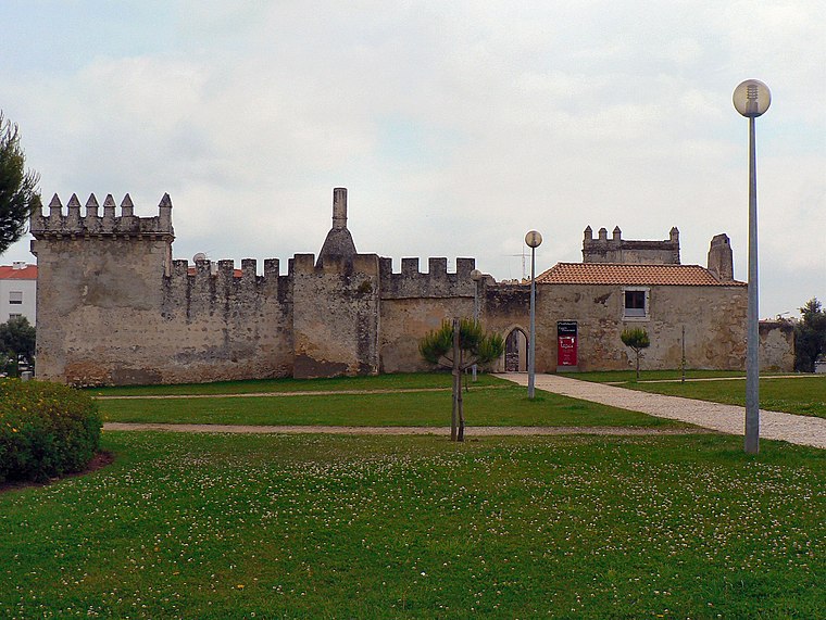
Photo: Juntas, CC BY-SA 2.5.
The Castle of Pirescoxe is a castle located in Santa Iria de Azoia, in the municipality of Loures, Portugal. It is classified by IGESPAR as a site of public interest. Castle of Pirescoxe is situated 2 km north of Escola Básica n.º 2 de São João da Talha.
Bobadela train station
Railway stop

Photo: Nuno Morão, CC BY-SA 2.0.
Bobadela train station is a railway stop, which is situated 1½ km south of Escola Básica n.º 2 de São João da Talha.
Places in the Area
Nearby places include Bobadela and Pirescoxe.


Unhos
Village

Photo: Juntas, CC BY-SA 2.5.
Unhos is a village, which is situated 2½ km west of Escola Básica n.º 2 de São João da Talha.
Escola Básica n.º 2 de São João da Talha
- Category: education
- Location: Santa Iria de Azoia, São João da Talha e Bobadela, Loures, Lisbon District, Portugal, Iberia, Europe
- View on OpenStreetMap
Latitude
38.82106° or 38° 49′ 16″ northLongitude
-9.09633° or 9° 5′ 47″ westOperator
Agrupamento de Escolas de São João da Talha, LouresOpen location code
8CCGRWC3+CFOpenStreetMap ID
way 1275252562OpenStreetMap feature
amenity=school
This page is based on OpenStreetMap, Wikidata, and Wikimedia Commons.
We’d love your help improving our open data sources. Thank you for contributing.
Satellite Map
Discover Escola Básica n.º 2 de São João da Talha from above in high-definition satellite imagery.
Notable Places Nearby
Highlights include Campo do Sport Clube Sanjoanense and Cimiterio de São João da Talha.
Nearby Places
Explore places such as Rua 25 de Abril Frente 4 and MARVIMAR, LDA. (1).
Portugal: Must-Visit Destinations
Delve into Lisbon, Caldas da Rainha, Porto, and Coimbra.
Curious Places to Discover
Uncover intriguing places from every corner of the globe.
About Mapcarta. Data © OpenStreetMap contributors and available under the Open Database License". Text is available under the CC BY-SA 4.0 license, except for photos, directions, and the map. Photo: Vitor Oliveira, CC BY-SA 2.0.