Pont de Tarragnoz sur le canal
Pont de Tarragnoz sur le canal is a bridge in Besançon, Doubs, Bourgogne-Franche-Comté. Pont de Tarragnoz sur le canal is situated nearby to the park Parc Notre-Dame, as well as near the tower Tour Notre-Dame.| Tap on a place to explore it |
Places of Interest Nearby
Highlights include Citadel of Besançon and Besançon Cathedral.
Citadel of Besançon
Castle
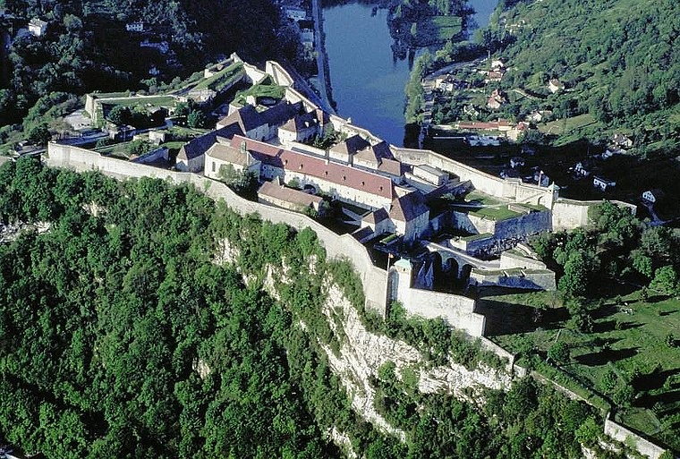
Photo: Wikimedia, CC BY-SA 3.0.
The Citadel of Besançon is a 17th-century fortress in Franche-Comté, France. It is one of the finest masterpieces of military architecture designed by Sébastien Le Prestre de Vauban. Citadel of Besançon is situated 210 metres east of Pont de Tarragnoz sur le canal.
Besançon Cathedral
Church

Photo: Wikimedia, CC BY-SA 3.0.
Besançon Cathedral is a Roman Catholic church dedicated to Saint John located in the city of Besançon, France. It is the seat of the Archbishop of Besançon. Besançon Cathedral is situated 420 metres north of Pont de Tarragnoz sur le canal.
Porte Noire
City gate

Photo: Lantus, CC BY-SA 3.0.
The Porte Noire is a Roman triumphal arch in Besançon, France. The limestone arch was located at the southern end of the cardo, the main north-to-south route of a Roman city. Porte Noire is situated 470 metres north of Pont de Tarragnoz sur le canal.
Places in the Area
Nearby places include Tarragnoz and La Gare d’Eau.


Pont de Tarragnoz sur le canal
- Type: Bridge
- Category: transportation
- Location: Besançon, Arrondissement of Besançon, Doubs, Franche-Comté, Bourgogne-Franche-Comté, France, Europe
- View on OpenStreetMap
Latitude
47.22986° or 47° 13′ 48″ northLongitude
6.03041° or 6° 1′ 50″ eastWidth
13 metres (43 feet)Operator
Conseil départemental du DoubsOpen location code
8FV862HJ+W5OpenStreetMap ID
way 1318891097OpenStreetMap feature
man_made=bridge
This page is based on OpenStreetMap, Wikidata, and Wikimedia Commons.
We’d love your help improving our open data sources. Thank you for contributing.
Satellite Map
Discover Pont de Tarragnoz sur le canal from above in high-definition satellite imagery.
Notable Places Nearby
Highlights include Parc Notre-Dame and Tour Notre-Dame.
Nearby Places
Explore places such as Canal Tarragnoz and Canal Tarragnoz.
Franche-Comté: Must-Visit Destinations
Delve into Vesoul, Dole, Saint-Claude, and Nans-sous-Sainte-Anne.
Curious Bridges to Discover
Uncover intriguing bridges from every corner of the globe.
About Mapcarta. Data © OpenStreetMap contributors and available under the Open Database License". Text is available under the CC BY-SA 4.0 license, except for photos, directions, and the map. Photo: Ludo29, CC BY-SA 3.0.