Seniorenwohnpark Blumeninsel
Seniorenwohnpark Blumeninsel is a social service facility in Wegeleben, Harz, Saxony-Anhalt which is located on Winkel. Seniorenwohnpark Blumeninsel is situated nearby to the town hall Rathaus / Verwaltungssitz Verbandsgemeinde Vorharz, as well as near Saint Peter and Paul church (Wegeleben).| Tap on a place to explore it |
Places of Interest Nearby
Highlights include Saint Peter and Paul church (Wegeleben).
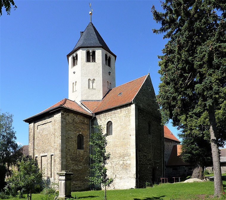
Saint Peter and Paul church (Wegeleben)
Church
 Saint Peter and Paul church (Wegeleben) is situated 240 metres northeast of Seniorenwohnpark Blumeninsel.
Places in the Area
Nearby places include Rodersdorf and Emersleben.
Rodersdorf
Village

Photo: Wolkenkratzer, CC BY-SA 4.0.
Rodersdorf is a village, which is situated 3 km east of Seniorenwohnpark Blumeninsel.
Emersleben
Village

Photo: Wolkenkratzer, CC BY-SA 4.0.
Emersleben is a village, which is situated 6 km north of Seniorenwohnpark Blumeninsel.
Gröningen Priory
Village
 Gröningen Priory was a Benedictine monastery, located west of Gröningen in present-day Saxony-Anhalt, Germany. The abbey church is part of the Romanesque Road scenic route. Gröningen Priory is situated 6 km north of Seniorenwohnpark Blumeninsel.
Seniorenwohnpark Blumeninsel
- Type: Social service facility
- Address: Winkel 13a, Wegeleben, 38828
- Location: Wegeleben, Harz, Saxony-Anhalt, Germany, Central Europe, Europe
- View on OpenStreetMap
Latitude
51.88371° or 51° 53′ 1″ northLongitude
11.17074° or 11° 10′ 15″ eastOperator
Wohnen im Alter Internet GmbHOpen location code
9F3HV5MC+F7OpenStreetMap ID
way 1329129505OpenStreetMap feature
amenity=social_facility
This page is based on OpenStreetMap, Wikidata, and Wikimedia Commons.
We’d love your help improving our open data sources. Thank you for contributing.
Satellite Map
Discover Seniorenwohnpark Blumeninsel from above in high-definition satellite imagery.
Notable Places Nearby
Highlights include Rathaus / Verwaltungssitz Verbandsgemeinde Vorharz and Freiwillige Feuerwehr Wegeleben.
Nearby Places
Explore places such as Strüma Metall- und Anlagenbau Torsten Strümpel and Bäckerei Seidenstücker.
Saxony-Anhalt: Must-Visit Destinations
Delve into Magdeburg, Halle, Wittenberg, and Quedlinburg.
Curious Social Service Facilities to Discover
Uncover intriguing social service facilities from every corner of the globe.
About Mapcarta. Data © OpenStreetMap contributors and available under the Open Database License". Text is available under the CC BY-SA 4.0 license, except for photos, directions, and the map. Photo: GMM, Public domain.