green space next to railroad
green space next to railroad is a grassland in Dallas, Texas. green space next to railroad is situated nearby to Lone Star Missionary Baptist Church, as well as near the park West Overlook.| Tap on a place to explore it |
Places of Interest Nearby
Highlights include Margaret Hunt Hill Bridge and Reunion Tower.
Margaret Hunt Hill Bridge
Bridge

Photo: Michael Barera, CC BY-SA 4.0.
The Margaret Hunt Hill Bridge is a cable-stayed bridge in Dallas, Texas, that spans the Trinity River. The bridge is named for Margaret Hunt Hill, an heiress and philanthropist. Margaret Hunt Hill Bridge is situated 2,500 feet northeast of green space next to railroad.
Reunion Tower

Photo: Loadmaster, CC BY-SA 3.0.
Reunion Tower is a 561 ft observation tower in Dallas, and one of the city's most recognizable landmarks. The tower is located at 300 Reunion Boulevard in the Reunion district of downtown Dallas, which is named after the mid-nineteenth century commune La Reunion. Reunion Tower is situated 1 mile east of green space next to railroad.
Dealey Plaza
Park
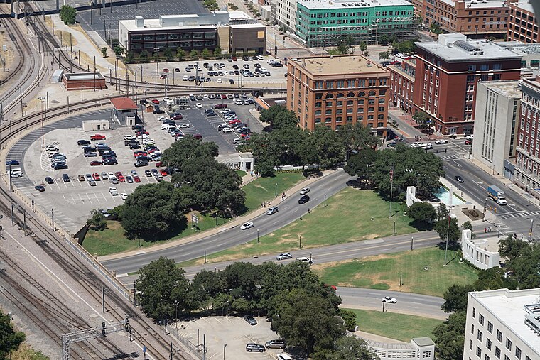
Photo: Michael Barera, CC BY-SA 4.0.
Dealey Plaza is a city park in the West End Historic District of downtown Dallas, Texas. It is sometimes called the "birthplace of Dallas". It was also the location of the assassination of John F.
Places in the Area
Nearby places include Design District and West End Historic District.
Design District
Quarter
The Design District is a neighborhood in central Dallas, Texas, just northwest of Downtown. It is bordered by I-35E on the north and east, Wycliff Avenue and the Trinity River levee on the west, and Continental Avenue on the south.
West End Historic District
Neighborhood

Photo: Drumguy8800, CC BY-SA 3.0.
The West End Historic District of Dallas, Texas, is a historic district that includes a 67.5-acre area in northwest downtown, generally north of Commerce, east of I-35E, west of Lamar and south of the Woodall Rodgers Freeway.
Downtown Dallas

Photo: Traveler100, CC BY-SA 3.0.
Downtown Dallas is the Central Business District of the city of Dallas. Traditionally defined as the area within the belt of freeways surrounding the centre, it is now deemed to have expanded to an area known as Uptown, north of the Woodall Rodgers Freeway thanks to the new walkable Klyde Warren Park, while in the east the center spills across US-75 into the Deep Ellum neighborhood.
green space next to railroad
- Type: Grassland
- Location: Dallas, Texas, United States, North America
- View on OpenStreetMap
Latitude
32.77554° or 32° 46′ 32″ northLongitude
-96.82815° or 96° 49′ 41″ westOpen location code
8645Q5GC+6POpenStreetMap ID
way 1330781225OpenStreetMap feature
natural=grassland
This page is based on OpenStreetMap, Wikidata, and Wikimedia Commons.
We’d love your help improving our open data sources. Thank you for contributing.
Satellite Map
Discover green space next to railroad from above in high-definition satellite imagery.
Notable Places Nearby
Highlights include Lone Star Missionary Baptist Church and West Overlook.
Nearby Places
Explore places such as residential parking and residential parking.
Texas: Must-Visit Destinations
Delve into Houston, Austin, Dallas, and San Antonio.
Curious Grasslands to Discover
Uncover intriguing grasslands from every corner of the globe.
About Mapcarta. Data © OpenStreetMap contributors and available under the Open Database License". Text is available under the CC BY-SA 4.0 license, except for photos, directions, and the map. Photo: Wikimedia, CC0.