The Wayne
The Wayne is a residential area in Lynchburg, Central Virginia, Virginia which is located on Main Street. The Wayne is situated nearby to the church Harvest Worship Center, as well as near Riverfront Park.| Tap on a place to explore it |
Places of Interest Nearby
Highlights include Carter Glass Memorial Bridge and Bragassa Toy Store.
Carter Glass Memorial Bridge
Bridge
Carter Glass Memorial Bridge crosses the James River between the independent city of Lynchburg and Amherst County, Virginia, Lynchburg Expressway. The bridge carries U.S. Route 29 Business, and it was named in 1949 in honor of former U.S. Carter Glass Memorial Bridge is situated 960 feet northeast of The Wayne.
Bragassa Toy Store
Historic building

Photo: Pubdog, Public domain.
The Bragassa Toy Store is a historic commercial building located in Lynchburg, Virginia, United States. In 1871, Francisco Bragassa purchased the property and in 1875 to 1876, he built the confectionery and toy store in Italianate style. Bragassa Toy Store is situated 1,600 feet northwest of The Wayne.
Lower Basin Historic District
Historic site

Photo: Pubdog, Public domain.
The Lower Basin Historic District is a national historic district located in Lynchburg, Virginia. The district defines a commercial and industrial warehouse area located between the downtown commercial area to the south and the James River waterfront to the north. Lower Basin Historic District is situated 1,800 feet northwest of The Wayne.
Places in the Area
Nearby places include Diamond Hill Historic District and Kemper Street Industrial Historic District.
Diamond Hill Historic District
Neighborhood

Photo: Pubdog, Public domain.
The Diamond Hill Historic District is a national historic district located in Lynchburg, Virginia. The district is irregularly shaped and approximately 14 blocks in area.
Kemper Street Industrial Historic District
Neighborhood
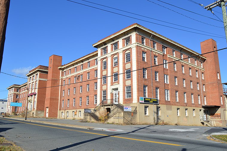
Photo: Nyttend, Public domain.
The Kemper Street Industrial Historic District encompasses a collection of industrial sites on Campbell Avenue and Kemper Street in Lynchburg, Virginia.
Madison Heights
Town

Photo: Carmenshields, CC BY 3.0.
Madison Heights is a census-designated place in Amherst County, Virginia, United States. The population was 10,893 at the 2020 census. It is part of the Lynchburg Metropolitan Statistical Area. Madison Heights is situated 1½ miles northeast of The Wayne.
The Wayne
- Type: Residential area
- Address: 1500 Main Street, Lynchburg, VA 24502
- Location: Lynchburg, Central Virginia, Virginia, South, United States, North America
- View on OpenStreetMap
Latitude
37.40949° or 37° 24′ 34″ northLongitude
-79.13686° or 79° 8′ 13″ westOpen location code
8792CV57+Q7OpenStreetMap ID
way 1343298041OpenStreetMap feature
landuse=residential
This page is based on OpenStreetMap, Wikidata, and Wikimedia Commons.
We’d love your help improving our open data sources. Thank you for contributing.
Satellite Map
Discover The Wayne from above in high-definition satellite imagery.
Notable Places Nearby
Highlights include Harvest Worship Center and Riverfront Park.
Nearby Places
Explore places such as {RA} Bistro and RiverWalk Parking.
Central Virginia: Must-Visit Destinations
Delve into Richmond, Charlottesville, Petersburg, and Danville.
Curious Residential Areas to Discover
Uncover intriguing residential areas from every corner of the globe.
About Mapcarta. Data © OpenStreetMap contributors and available under the Open Database License". Text is available under the CC BY-SA 4.0 license, except for photos, directions, and the map. Photo: Wikimedia, CC0.