Form construction site
Form construction site is in British Columbia, Canada. Form construction site is situated nearby to the restaurant Farmer’s Apprentice, as well as near the art gallery Charlotte Wall Works.| Tap on a place to explore it |
Places of Interest Nearby
Highlights include Farmer’s Apprentice and Douglas Reynolds Gallery.
Farmer’s Apprentice
Restaurant
Farmer's Apprentice is a restaurant in Vancouver, British Columbia, Canada. Neighboring Grapes & Soda has been described as a "sister" wine bar.
Douglas Reynolds Gallery
Art gallery
Douglas Reynolds Gallery specializes in world renowned Indigenous Northwest Coast art. Working directly with a variety of artists, the gallery represents cultural groups spanning from the Haida and Tlingit in Northern British Columbia, to the Coast Salish in the Vancouver area and Northern Washington state. Douglas Reynolds Gallery is situated 150 metres southeast of Form construction site.
Stanley Industrial Alliance Stage
Theater building

Photo: Wikimedia, CC BY-SA 3.0.
The Stanley BFL Canada Stage is a landmark theatre at 12th Avenue and Granville Street in Vancouver, British Columbia, which serves as the main stage for the Arts Club Theatre Company. Stanley Industrial Alliance Stage is situated 520 metres south of Form construction site.
Places in the Area
Nearby places include Granville Island and Kitsilano.
Granville Island
Neighborhood
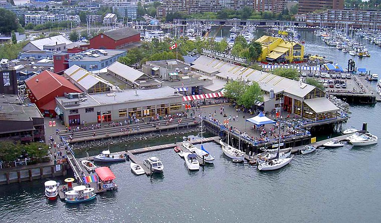
Photo: Zhatt, Public domain.
Granville Island is a peninsula and shopping district in the Fairview neighbourhood of Vancouver, British Columbia, Canada, across False Creek from Downtown Vancouver, under the south end of the Granville Street Bridge.
Kitsilano
Suburb

Photo: Flying Penguin, CC BY-SA 3.0.
Kitsilano, South Granville and Granville Island form most of the northern part of the Vancouver west side. In the 1960s Kits was a neighbourhood where hippies "tuned in and dropped out" but today it has some of Vancouver's most expensive properties.
Shaughnessy
Suburb
Shaughnessy is an almost-entirely residential neighbourhood in Vancouver, British Columbia, Canada, spanning about 447 hectares in a relatively central locale.
Form construction site
- Type: Construction
- Location: British Columbia, Canada, North America
- View on OpenStreetMap
Latitude
49.26597° or 49° 15′ 58″ northLongitude
-123.13961° or 123° 8′ 23″ westOperator
Anthem PropertiesOpen location code
84XR7V86+95OpenStreetMap ID
way 1351502092OpenStreetMap feature
landuse=construction
This page is based on OpenStreetMap, Wikidata, and Wikimedia Commons.
We’d love your help improving our open data sources. Thank you for contributing.
Satellite Map
Discover Form construction site from above in high-definition satellite imagery.
Notable Places Nearby
Highlights include Charlotte Wall Works and Centre culturel francophone.
Nearby Places
Explore places such as Grapes and Soda and Atomic Bike Shop.
British Columbia: Must-Visit Destinations
Delve into Vancouver, Victoria, North Vancouver, and City Centre.
Curious Places to Discover
Uncover intriguing places from every corner of the globe.
About Mapcarta. Data © OpenStreetMap contributors and available under the Open Database License". Text is available under the CC BY-SA 4.0 license, except for photos, directions, and the map. Photo: Wikimedia, CC0.