Queen Louise’s Bridge
Dronning Louises Bro is a bridge across The Lakes in central Copenhagen, Denmark. It joins Frederiksborggade in Indre By with Nørrebrogade in Nørrebro and separates Sortedam Lake to the northeast from Peblinge Lake to the south west.| Tap on a place to explore it |
Photo: Wikimedia, CC BY-SA 3.0.
- Type: Bridge
- Description: bridge in Denmark
- Also known as: “Dronning Louises Bro”
Places of Interest Nearby
Highlights include Søtorvet and castle Rosenborg.
Søtorvet
Square

Photo: Martin Roell, CC BY-SA 2.0.
Søtorvet is an elegant late 19th century residential development facing The Lakes in Copenhagen, Denmark. It flanks the end of Frederiksborggade, where it turns into the Queen Louise Bridge, at the intersection with Øster and Nørre Søgade. Søtorvet is situated 110 metres southeast of Queen Louise’s Bridge.
castle Rosenborg
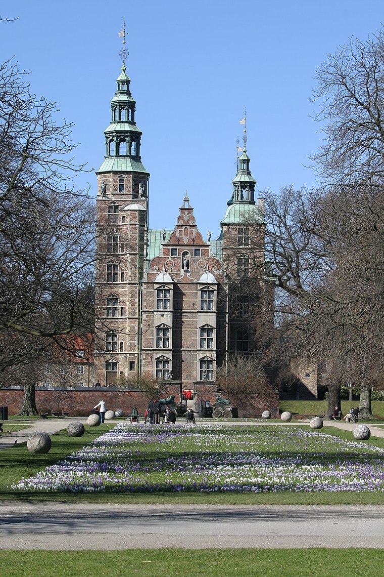
Photo: Wikimedia, CC BY-SA 3.0.
Rosenborg Castle is a renaissance castle in Copenhagen, Denmark. The castle was originally built as a country summerhouse in 1606 and is an example of Christian IV's many architectural projects. castle Rosenborg is situated 1 km east of Queen Louise’s Bridge.
Embassy of Croatia
Government office

Photo: Dannebrog Spy, CC BY-SA 4.0.
Embassy of Croatia is a government office, which is situated 170 metres southeast of Queen Louise’s Bridge.
Places in the Area
Nearby places include Copenhagen and Nuuks Plads.
Copenhagen

Photo: Jjtkk, CC BY-SA 3.0.
Copenhagen is the capital city of Denmark and forms the moderate conurbation that one million Danes call home. It is big enough to form a small Danish metropolis, with shopping, culture and nightlife par excellence, yet small enough still to feel intimate and be safe.

Nyboder
Quarter

Photo: Wikimedia, CC BY-SA 3.0.
Nyboder is a historic row house district of former Naval barracks in Copenhagen, Denmark. It was planned and first built by Christian IV to accommodate a need for housing for the personnel of the rapidly growing Royal Danish Navy and their families during that time.
Queen Louise’s Bridge
- Categories: road bridge and transportation
- Location: Indre By, Copenhagen municipality, Capital Region, Denmark, Nordic countries, Europe
- View on OpenStreetMap
Latitude
55.68673° or 55° 41′ 12″ northLongitude
12.56377° or 12° 33′ 50″ eastInception
1885Named after
Louise of Hesse-KasselOpen location code
9F7JMHP7+MGOpenStreetMap ID
way 1356284878OpenStreetMap feature
man_made=bridgeWikidata ID
Q3428996
This page is based on OpenStreetMap, Wikidata, Wikimedia Commons, and Wikipedia.
We’d love your help improving our open data sources. Thank you for contributing.
Satellite Map
Discover Queen Louise’s Bridge from above in high-definition satellite imagery.
In Other Languages
From Danish to Swedish—“Queen Louise’s Bridge” goes by many names.
- Danish: “Dronning Louises Bro”
- Danish: “Peblingebroen”
- Faroese: “Dronning Louises Bro”
- French: “Dronning Louises Bro”
- German: “Dronning Louises Bro”
- German: “Königin-Luise-Brücke”
- Icelandic: “Dronning Louises Bro”
- Kalaallisut: “Dronning Louises Bro”
- Norwegian Bokmål: “Dronning Louises Bro”
- Norwegian Nynorsk: “Dronning Louises Bro”
- Norwegian: “Dronning Louises bro”
- Swedish: “Dronning Louises Bro”
Notable Places Nearby
Highlights include FOOD CLUB and Oxholm Hall.
Nearby Places
Explore places such as Siddende unge mennesker and Dr. Louises Bro.
Denmark: Must-Visit Destinations
Delve into Copenhagen, Aarhus, Odense, and Aalborg.
Curious Bridges to Discover
Uncover intriguing bridges from every corner of the globe.
About Mapcarta. Data © OpenStreetMap contributors and available under the Open Database License". Text is available under the CC BY-SA 4.0 license, except for photos, directions, and the map. Description text is based on the Wikipedia page “Queen Louise’s Bridge”. Photo: Wikimedia, CC BY-SA 3.0.