Orgelteile Otto Heuss
Orgelteile Otto Heuss is an industrial building in Lich, Giessen, Hesse which is located on Amtsgerichtsstraße. Orgelteile Otto Heuss is situated nearby to the community center Bürgerhaus Lich, as well as near the movie theater Traumstern.| Tap on a place to explore it |
- Email: info@ottoheuss.com
- Type: Industrial building
- Address: Amtsgerichtsstraße 12, Lich, 35423
Places of Interest Nearby
Highlights include Traumstern and Marienstiftskirche.
Traumstern
Movie theater
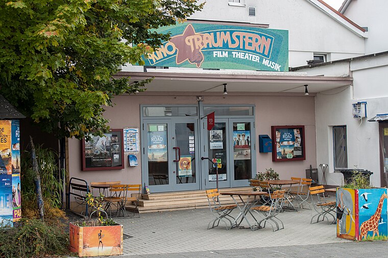
Photo: Stefan2901, CC BY-SA 3.0.
Traumstern is a movie theater, which is situated 240 metres east of Orgelteile Otto Heuss.
Marienstiftskirche
Church

Photo: Cherubino, CC BY-SA 3.0.
The Marienstiftskirche is a Lutheran three-aisled hall church in Lich, Middle Hesse, Germany. It was built between 1510 and 1537, making it the last Late Gothic hall church to be built in Hesse. Marienstiftskirche is situated 370 metres east of Orgelteile Otto Heuss.
Unterstadt 1
Town hall

Photo: Cherubino, CC BY-SA 3.0.
Unterstadt 1 is a town hall, which is situated 420 metres east of Orgelteile Otto Heuss.
Places in the Area
Nearby places include Holzheim and Annerod.

Annerod
Village

Photo: Cherubino, CC BY-SA 4.0.
Annerod is a small village, part of the municipality Fernwald, in Germany between Gießen and Großen-Buseck approximately 70 km north of Frankfurt. Annerod has a population of about 3200 people. Annerod is situated 8 km northwest of Orgelteile Otto Heuss.
Orgelteile Otto Heuss
- Categories: building, workshop, and industry
- Location: Lich, Giessen, North Hesse, Hesse, Germany, Central Europe, Europe
- View on OpenStreetMap
Latitude
50.52126° or 50° 31′ 17″ northLongitude
8.81418° or 8° 48′ 51″ eastOpen location code
9F2CGRC7+GMOpenStreetMap ID
way 136228512OpenStreetMap feature
building=industrialOpenStreetMap feature
craft=organ_builder
This page is based on OpenStreetMap, Wikidata, and Wikimedia Commons.
We’d love your help improving our open data sources. Thank you for contributing.
Satellite Map
Discover Orgelteile Otto Heuss from above in high-definition satellite imagery.
Notable Places Nearby
Highlights include Bürgerhaus Lich and Sim Racing Center.
Nearby Places
Explore places such as Heuss and Ferienwohnung Glöckner.
North Hesse: Must-Visit Destinations
Delve into Kassel, Wetzlar, Marburg, and Fulda.
Curious Industrial Buildings to Discover
Uncover intriguing industrial buildings from every corner of the globe.
About Mapcarta. Data © OpenStreetMap contributors and available under the Open Database License". Text is available under the CC BY-SA 4.0 license, except for photos, directions, and the map. Photo: Kreuzschnabel, CC BY-SA 3.0.