Hanlan’s Point Water Taxis
Hanlan’s Point Water Taxis is a passenger ship terminal in Old Toronto, Toronto, Ontario. Hanlan’s Point Water Taxis is situated nearby to Ned Hanlan ship, as well as near the islet Mugg’s Island.| Tap on a place to explore it |
Places of Interest Nearby
Highlights include CN Tower and Rogers Centre.
CN Tower

Photo: Taxiarchos228, CC BY-SA 3.0.
The CN Tower is a 553.3 m-high communications and observation tower in Toronto, Ontario, Canada. Completed in 1976, it is located in downtown Toronto, built on the former Railway Lands. CN Tower is situated 1½ km north of Hanlan’s Point Water Taxis.
Rogers Centre
Stadium

Photo: Fabian Roudra Baroi, CC BY-SA 4.0.
Rogers Centre is a retractable roof stadium in downtown Toronto, Ontario, Canada, situated at the base of the CN Tower near the northern shore of Lake Ontario. Rogers Centre is situated 1½ km north of Hanlan’s Point Water Taxis.
Scotiabank Arena
Stadium
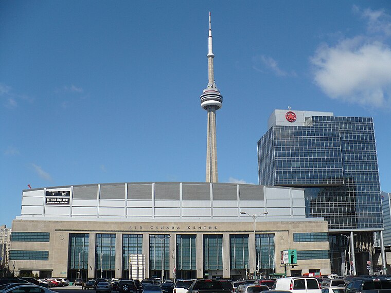
Photo: Secondarywaltz, Public domain.
Scotiabank Arena, formerly known as Air Canada Centre, is a multi-purposed arena located on Bay Street in downtown Toronto, Ontario, Canada. It is the home of the Toronto Raptors of the National Basketball Association and the Toronto Maple Leafs of the National Hockey League. Scotiabank Arena is situated 2 km northeast of Hanlan’s Point Water Taxis.
Places in the Area
Nearby places include CityPlace and Fort York.
CityPlace
Neighborhood
 CityPlace is a neighbourhood in downtown Toronto, Ontario, Canada, within the former Railway Lands. When completed, this area will be the largest residential development ever created in Toronto.
Fort York
Neighborhood

Photo: SimonP, CC BY-SA 3.0.
Fort York, also known as Garrison, is a neighbourhood in Toronto, Ontario, Canada, located west of Downtown Toronto, north of Billy Bishop Toronto City Airport, and east of Exhibition Place along the shores of Lake Ontario.
Harbourfront

Photo: Traveler100, CC BY-SA 3.0.
The Harbourfront neighbourhood in Toronto encompasses the area from the lakeshore corridor railway line in the north down to Lake Ontario in the south and from Exhibition Place in the west to Parliament Street in the east.
Hanlan’s Point Water Taxis
- Type: Passenger ship terminal
- Categories: wharf and transportation
- Location: Old Toronto, Toronto, Greater Toronto Area, Ontario, Canada, North America
- View on OpenStreetMap
Latitude
43.62829° or 43° 37′ 42″ northLongitude
-79.38924° or 79° 23′ 21″ westOpen location code
87M2JJH6+88OpenStreetMap ID
way 1375105747OpenStreetMap feature
amenity=ferry_terminalOpenStreetMap feature
man_made=quayOpenStreetMap feature
public_transport=yes
This page is based on OpenStreetMap, Wikidata, and Wikimedia Commons.
We’d love your help improving our open data sources. Thank you for contributing.
Satellite Map
Discover Hanlan’s Point Water Taxis from above in high-definition satellite imagery.
Notable Places Nearby
Highlights include Ned Hanlan ship and Mugg’s Island.
Nearby Places
Explore places such as Hanlan’s Point Ferry Dock and Ned Hanlan.
Toronto: Must-Visit Destinations
Delve into Yorkville and the Annex, Midtown, East End, and Downtown East.
Curious Passenger Ship Terminals to Discover
Uncover intriguing passenger ship terminals from every corner of the globe.
About Mapcarta. Data © OpenStreetMap contributors and available under the Open Database License". Text is available under the CC BY-SA 4.0 license, except for photos, directions, and the map. Photo: S23678, CC BY-SA 3.0.