中国人民解放军信息支援部队工程大学
中国人民解放军信息支援部队工程大学 is an university in Hubei, South-central China. 中国人民解放军信息支援部队工程大学 is situated nearby to the police station 劳动街派出所, as well as near the playground 育才高中足球场.| Tap on a place to explore it |
Places of Interest Nearby
Highlights include Dazhimen railway station and Sanyang Road.
Dazhimen railway station
Historic building
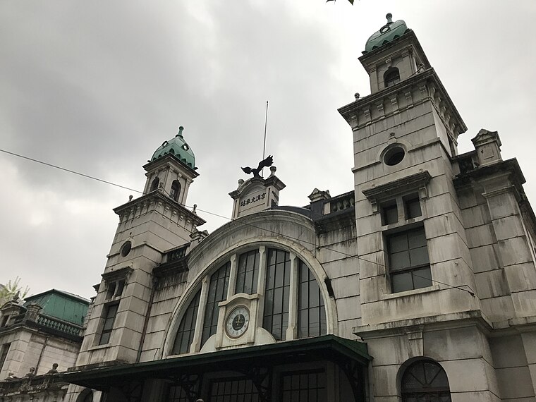
Photo: Time-137, CC BY-SA 4.0.
Dazhimen or Ta-chih-men railway station in Wuhan, China, was the southern terminus of the Beijing–Hankou railway. It is located at the intersection of Jinghan Road and Chezhan Road in Jiang'an District, part of the former city of Hankou. Dazhimen railway station is situated 1 km south of 中国人民解放军信息支援部队工程大学.
Sanyang Road
Metro station

Photo: Painjet, CC BY-SA 4.0.
Sanyang Road Station serves as an interchange station of Line 1 and Line 7 of Wuhan Metro. The elevated station entered revenue service along with the completion of Line 1, Phase 1 on July 28, 2004, and the underground station entered service on October 1, 2018 with the opening of Line 7. Sanyang Road is situated 730 metres southeast of 中国人民解放军信息支援部队工程大学.
British Consulate
Government office

Photo: ZhengZhou, CC BY-SA 4.0.
British Consulate is a government office, which is situated 1¼ km east of 中国人民解放军信息支援部队工程大学.
Places in the Area
Nearby places include Wuhan and Yiyuan Subdistrict.
Wuhan
 Wuhan is the capital of Hubei Province in China and a major port on the Yangtze River. Also known as "River City," Wuhan is the largest metropolis in central China.
Yiyuan Subdistrict
Suburb
Yiyuan Subdistrict is a subdistrict in Jiang'an District, Wuhan, Hubei, China. As of 2023, it administers seven residential communities: Yuefei, Tongxing, Sanyang, Tianjin, Yangzi, Tongfu, and Dongting.
Beihu
Suburb
Beihu Subdistrict is a subdistrict in Jianghan District, Wuhan, Hubei, China. Beihu is situated 3 km west of 中国人民解放军信息支援部队工程大学.
中国人民解放军信息支援部队工程大学
- Type: University
- Categories: military installation and education
- Location: Hubei, South-central China, China, East Asia, Asia
- View on OpenStreetMap
Latitude
30.60663° or 30° 36′ 24″ northLongitude
114.29102° or 114° 17′ 28″ eastOperator
中国人民解放军信息支援部队Open location code
8P2PJ74R+MCOpenStreetMap ID
way 1387302971OpenStreetMap feature
amenity=universityOpenStreetMap feature
landuse=military
This page is based on OpenStreetMap, Wikidata, and Wikimedia Commons.
We’d love your help improving our open data sources. Thank you for contributing.
Satellite Map
Discover 中国人民解放军信息支援部队工程大学 from above in high-definition satellite imagery.
Notable Places Nearby
Highlights include 劳动街派出所 and 育才高中足球场.
Nearby Places
Explore places such as 育高食堂 and 育高教学楼1.
Hubei: Must-Visit Destinations
Delve into Wuhan, Yichang, Xiangyang, and Huangshi.
Curious Places to Discover
Uncover intriguing places from every corner of the globe.
About Mapcarta. Data © OpenStreetMap contributors and available under the Open Database License". Text is available under the CC BY-SA 4.0 license, except for photos, directions, and the map. Photo: Hshook, CC BY-SA 4.0.