Sepultura da Infanta Dona Maria
Sepultura da Infanta Dona Maria is a tomb in Carnide, Lisbon. Sepultura da Infanta Dona Maria is situated nearby to the spring Chafariz da Luz, as well as near the fountain Santuário da Nossa Senhora da Luz.| Tap on a place to explore it |
Places of Interest Nearby
Highlights include Estádio da Luz and Colombo Centre.
Estádio da Luz
Stadium
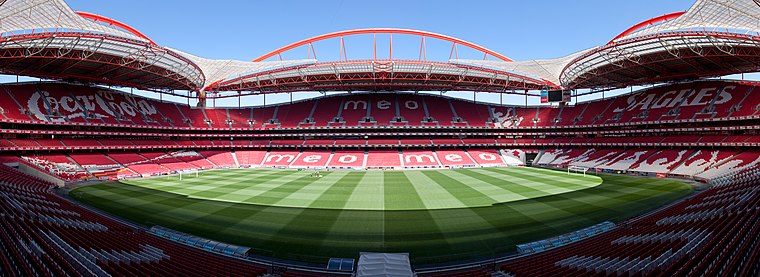
Photo: Massimo Catarinella, CC BY 3.0.
The Estádio da Luz, officially named Estádio do Sport Lisboa e Benfica, is a multi-purpose stadium located in Lisbon, Portugal. It is used mostly for association football matches, hosting the home games of Portuguese club Benfica, its owner. Estádio da Luz is situated 1 km south of Sepultura da Infanta Dona Maria.
Colombo Centre
Shopping center

Photo: Alvesgaspar, CC BY-SA 3.0.
The Colombo Centre is a shopping mall located in the parish of Carnide in Lisbon and attracts many visitors. It is situated next to the Lusíada avenue and the Segunda Circular; there is a bus terminal next to the building and the Lisbon Metro station Colégio Militar/Luz allows visitors easy access to Colombo. Colombo Centre is situated 720 metres southwest of Sepultura da Infanta Dona Maria.
Colégio Militar
School
 The Colégio Militar is a military secondary school in Lisbon, Portugal. It was founded by Marechal António Teixeira Rebello in 1803. Colégio Militar is situated 350 metres southeast of Sepultura da Infanta Dona Maria.
Places in the Area
Nearby places include Pontinha and São Domingos de Benfica.
Pontinha
Town
Pontinha, with an area of 4.64 km2, is a former civil parish in the municipality of Odivelas, Portugal. In 2013, the parish merged into the new parish Pontinha e Famões.
São Domingos de Benfica
Village
Photo: Massimo Catarinella, CC BY 3.0.
São Domingos de Benfica is a freguesia and district of Lisbon, the capital of Portugal. Located in northern Lisbon, São Domingos de Benfica is east of Benfica, south of Carnide, west of Alvalade, and north of Campolide. The population in 2011 was 33,043,…

Sepultura da Infanta Dona Maria
- Type: Tomb
- Categories: historic site and burial
- Location: Carnide, Lisbon, Lisbon District, Portugal, Iberia, Europe
- View on OpenStreetMap
Latitude
38.76048° or 38° 45′ 38″ northLongitude
-9.18485° or 9° 11′ 6″ westOpen location code
8CCGQR68+53OpenStreetMap ID
way 1424570145OpenStreetMap feature
historic=tomb
This page is based on OpenStreetMap, Wikidata, and Wikimedia Commons.
We’d love your help improving our open data sources. Thank you for contributing.
Satellite Map
Discover Sepultura da Infanta Dona Maria from above in high-definition satellite imagery.
Notable Places Nearby
Highlights include Chafariz da Luz and Santuário da Nossa Senhora da Luz.
Nearby Places
Explore places such as Fonte de Nossa Senhora da Luz and Santuário Nossa Senhora da Luz.
Lisbon: Must-Visit Destinations
Delve into Bairro Alto, Alfama, Baixa, and Belém.
Curious Tombs to Discover
Uncover intriguing tombs from every corner of the globe.
About Mapcarta. Data © OpenStreetMap contributors and available under the Open Database License". Text is available under the CC BY-SA 4.0 license, except for photos, directions, and the map. Photo: Alvesgaspar, CC BY-SA 3.0.