Fhz Halle
Fhz Halle is an ambulance station in Helmstedt, Brunswick Land, Lower Saxony. Fhz Halle is situated nearby to the motorhome stopover Stellpatz ‘Am Lappwald’, as well as near the dog park Hundetrainingszentru,m Helmstedt.| Tap on a place to explore it |
Places of Interest Nearby
Highlights include Lübbensteine and Juleum.
Lübbensteine
Archaeological site

Photo: Wikimedia, CC BY-SA 3.0.
Lübbensteine is an archaeological site, which is situated 2½ km south of Fhz Halle.
Juleum
Museum

Photo: Wikimedia, CC BY-SA 3.0.
Juleum is a museum, which is situated 3 km southeast of Fhz Halle.
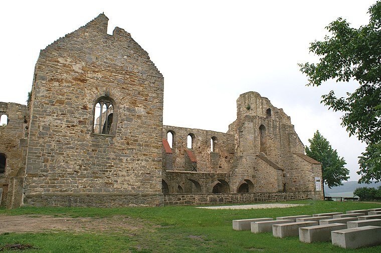
St. Ludger’s Abbey
Church

Photo: Times, CC BY-SA 3.0.
St. Ludger's Abbey was a former monastery of the Benedictine Order in Helmstedt, Lower Saxony, founded by Saint Ludger around 800. Until it was secularised in 1802 it was an Imperial Abbey, with sovereignty over the whole town of Helmstedt until the 15th century. St. Ludger’s Abbey is situated 3½ km southeast of Fhz Halle.
Places in the Area
Nearby places include Mariental and Walbeck.
Mariental
Village

Photo: Harald Hartge, Public domain.
Mariental is a municipality in the district of Helmstedt, in Lower Saxony, Germany. The Municipality Mariental includes the villages of Mariental-Dorf and Mariental-Horst. See also Mariental Abbey. Mariental is situated 3 km north of Fhz Halle.
Walbeck
Village
 Walbeck is a village and a former municipality in the Börde district in Saxony-Anhalt, Germany. Since 1 January 2010, it is part of the town Oebisfelde-Weferlingen. Its population is 688. Walbeck is situated 6 km northeast of Fhz Halle.
Grasleben
Village

Photo: Roger Wollstadt, CC BY-SA 2.0.
Grasleben is a municipality in the district of Helmstedt, in Lower Saxony, Germany. It is situated approximately 10 km north of Helmstedt, and 20 km southeast of Wolfsburg. Grasleben is situated 6 km north of Fhz Halle.
Fhz Halle
- Type: Ambulance station
- Categories: building and health care
- Location: Helmstedt, Helmstedt (district), Brunswick Land, Lower Saxony, Germany, Central Europe, Europe
- View on OpenStreetMap
Latitude
52.2519° or 52° 15′ 7″ northLongitude
10.98765° or 10° 59′ 16″ eastOpen location code
9F4G7X2Q+Q3OpenStreetMap ID
way 1428925080OpenStreetMap feature
building=garage
This page is based on OpenStreetMap, Wikidata, and Wikimedia Commons.
We’d love your help improving our open data sources. Thank you for contributing.
Satellite Map
Discover Fhz Halle from above in high-definition satellite imagery.
Notable Places Nearby
Highlights include Stellpatz ‘Am Lappwald’ and Hundetrainingszentru,m Helmstedt.
Nearby Places
Explore places such as Neubaufläche Rettungsdienst and Gewerbegebiet Neue Breite Nord.
Brunswick Land: Must-Visit Destinations
Delve into Brunswick, Wolfsburg, Salzgitter, and Wolfenbüttel.
Curious Ambulance Stations to Discover
Uncover intriguing ambulance stations from every corner of the globe.
About Mapcarta. Data © OpenStreetMap contributors and available under the Open Database License". Text is available under the CC BY-SA 4.0 license, except for photos, directions, and the map. Photo: Times, CC BY-SA 3.0.