Wood Duck Pond
Wood Duck Pond is a pond in Westchester County, Downstate New York, New York. Wood Duck Pond is situated nearby to the nature reserve Warburg Park, as well as near the reservoir Still Lake.| Tap on a place to explore it |
Places of Interest Nearby
Highlights include Carrie Chapman Catt House.
Carrie Chapman Catt House
Historic building
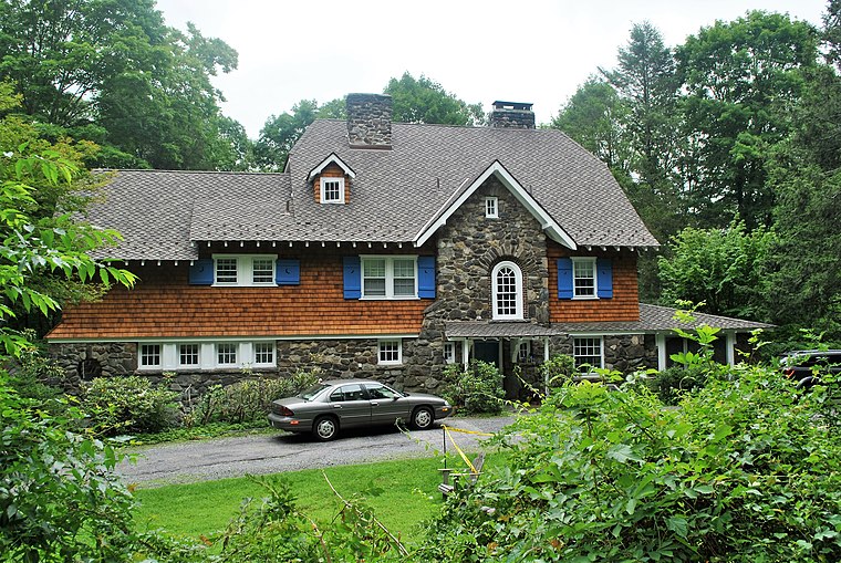
Photo: Elisa.rolle, CC BY-SA 4.0.
The Carrie Chapman Catt House, also known as Juniper Ledge, is located on Ryder Road in the town of New Castle, New York, United States. It is an Arts and Crafts-style building from the early 20th century. Carrie Chapman Catt House is situated 1½ miles south of Wood Duck Pond.
Places in the Area
Nearby places include Millwood and Chappaqua.
Millwood
Village
Millwood is a hamlet and census-designated place located in the town of New Castle, New York, United States in Westchester County. It was originally settled as Sarlesville.
Chappaqua

Photo: Daniel Case, CC BY-SA 3.0.
Chappaqua is a hamlet in the Town of New Castle in northern Westchester County, New York. Its most notable current residents are former President Bill Clinton and former Secretary of State Hillary Clinton.
Briarcliff Manor
 Briarcliff Manor is a charming village in Westchester County, New York situated on the Hudson River, and is home to 7,600 people. It has a very small and walkable downtown with a large density of shops and restaurants, and is very nature-oriented.
Wood Duck Pond
- Type: Pond
- Category: body of water
- Location: Westchester County, Downstate New York, New York, Mid-Atlantic, United States, North America
- View on OpenStreetMap
Latitude
41.19642° or 41° 11′ 47″ northLongitude
-73.80444° or 73° 48′ 16″ westOpen location code
87H855WW+H6OpenStreetMap ID
way 1431609438OpenStreetMap feature
natural=waterOpenStreetMap feature
water=pond
This page is based on OpenStreetMap, Wikidata, and Wikimedia Commons.
We’d love your help improving our open data sources. Thank you for contributing.
Satellite Map
Discover Wood Duck Pond from above in high-definition satellite imagery.
Places with the Same Name
Discover other places named “Wood Duck Pond”.
Notable Places Nearby
Highlights include Warburg Park and Still Lake.
Nearby Places
Explore places such as Millwood Substation and Rocky’s Millwood Deli.
Westchester County: Must-Visit Destinations
Delve into Yonkers, White Plains, New Rochelle, and Mount Vernon.
Curious Ponds to Discover
Uncover intriguing ponds from every corner of the globe.
About Mapcarta. Data © OpenStreetMap contributors and available under the Open Database License". Text is available under the CC BY-SA 4.0 license, except for photos, directions, and the map. Photo: Wikimedia, CC0.