Mt. Pleasant Elementary School Playground
Mt. Pleasant Elementary School Playground is a playground in Livingston Township, Essex County, New Jersey. Mt. Pleasant Elementary School Playground is situated nearby to Mt. Pleasant Middle School, as well as near the synagogue Temple Beth Shalom.| Tap on a place to explore it |
Places of Interest Nearby
Highlights include Mt. Pleasant Middle School and Harrison Elementary School.
Mt. Pleasant Middle School
School
The Livingston Public Schools is a comprehensive community public school district that serves students in pre-kindergarten through twelfth grade from Livingston, in Essex County, in the U.S. state of New Jersey. Mt. Pleasant Middle School is situated 330 feet north of Mt. Pleasant Elementary School Playground.
Harrison Elementary School
School
The Livingston Public Schools is a comprehensive community public school district that serves students in pre-kindergarten through twelfth grade from Livingston, in Essex County, in the U.S. state of New Jersey. Harrison Elementary School is situated 4,000 feet northwest of Mt. Pleasant Elementary School Playground.
Riker Hill Art Park
Nature reserve
Riker Hill Art Park is a former Nike Missile base which has become an artistic community in Livingston, Essex County, New Jersey. Together with the Walter Kidde Dinosaur Park and Becker Park, it is a part of the Riker Hill Complex. Riker Hill Art Park is situated 1½ miles northwest of Mt. Pleasant Elementary School Playground.
Places in the Area
Nearby places include Livingston and Roseland.
Livingston
Town

Photo: Jared Kofsky, CC BY-SA 3.0.
Livingston is a township in Essex County, in the U.S. state of New Jersey. As of the 2020 United States census, the township's population was 31,330, its highest decennial count ever and an increase of 1,964 from 29,366 recorded at the 2010 census, which in turn reflected an increase of 1,975 from the 27,391 counted in the 2000 census.
Roseland
Village
Photo: Jag9889, CC BY-SA 4.0.
Roseland is a borough in western Essex County, in the U.S. state of New Jersey. As of the 2020 United States census, the borough's population was 6,299, an increase of 480 from the 2010 census count of 5,819, which in turn reflected an increase of 521 from the 5,298 counted in the 2000 census. Roseland is situated 2 miles north of Mt. Pleasant Elementary School Playground.
Essex Fells
Village
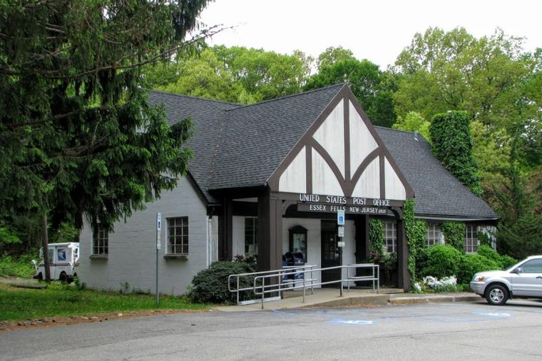
Photo: NAB1997, CC BY-SA 4.0.
Essex Fells is a borough in Essex County, in the U.S. state of New Jersey. As of the 2020 United States census, the borough's population was 2,244, an increase of 131 from the 2010 census count of 2,113, which in turn had reflected a decline of 49 from the 2,162 counted in the 2000 census. Essex Fells is situated 2 miles northeast of Mt. Pleasant Elementary School Playground.
Mt. Pleasant Elementary School Playground
- Type: Playground
- Category: recreation area
- Location: Livingston Township, Essex County, Gateway, New Jersey, Mid-Atlantic, United States, North America
- View on OpenStreetMap
Latitude
40.79543° or 40° 47′ 44″ northLongitude
-74.30363° or 74° 18′ 13″ westOpen location code
87G7QMWW+5GOpenStreetMap ID
way 1434885787OpenStreetMap feature
leisure=playground
This page is based on OpenStreetMap, Wikidata, and Wikimedia Commons.
We’d love your help improving our open data sources. Thank you for contributing.
Satellite Map
Discover Mt. Pleasant Elementary School Playground from above in high-definition satellite imagery.
Notable Places Nearby
Highlights include Temple Beth Shalom and Saint Peter Church.
Nearby Places
Explore places such as Mount Pleasant Elementary School and Livingston Huaxia Chinese School.
Essex County: Must-Visit Destinations
Delve into Newark, Newark Liberty International Airport, Montclair, and Maplewood.
Curious Playgrounds to Discover
Uncover intriguing playgrounds from every corner of the globe.
About Mapcarta. Data © OpenStreetMap contributors and available under the Open Database License". Text is available under the CC BY-SA 4.0 license, except for photos, directions, and the map. Photo: King of Hearts, CC BY-SA 3.0.