BP
BP is in Santo Antão e São Julião do Tojal, Loures, Lisbon District. BP is situated nearby to the park Jardim de Sto Antão do Tojal, as well as near the playground Parque Infantil de Santo Antão do Tojal.| Tap on a place to explore it |
Places of Interest Nearby
Highlights include Palácio da Mitra, aqueduto, pombais, chafarizes, igreja, monumental portão de entrada e toda a área murada da antiga quinta and Igreja Matriz de Santo Antão do Tojal.
Palácio da Mitra, aqueduto, pombais, chafarizes, igreja, monumental portão de entrada e toda a área murada da antiga quinta
Castle
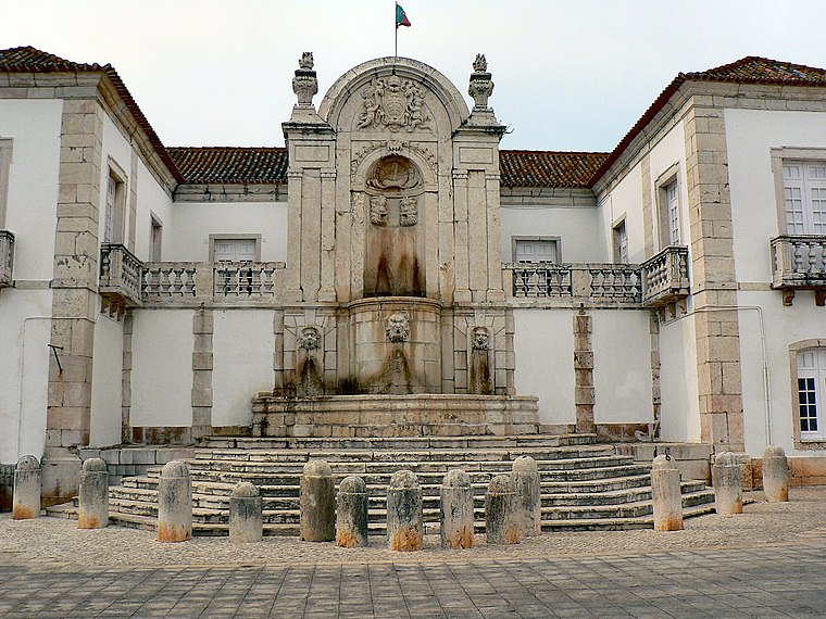
Photo: Juntas, CC BY-SA 2.5.
Palácio da Mitra, aqueduto, pombais, chafarizes, igreja, monumental portão de entrada e toda a área murada da antiga quinta is a castle, which is situated 670 metres southeast of BP.
Igreja Matriz de Santo Antão do Tojal
Church

Photo: Juntas, CC BY-SA 2.5.
Igreja Matriz de Santo Antão do Tojal is a church, which is situated 660 metres southeast of BP.
Igreja de São Julião do Tojal
Church

Photo: Juntas, CC BY-SA 4.0.
Igreja de São Julião do Tojal is a church, which is situated 1¼ km east of BP.
Places in the Area
Nearby places include Freguesia de Santo Antão do Tojal and Fanhões.
Freguesia de Santo Antão do Tojal
Village

Photo: Juntas, CC BY-SA 2.5.
Freguesia de Santo Antão do Tojal is a village.
Fanhões
Village

Photo: Wikimedia, CC BY-SA 2.5.
Fanhões is a village, which is situated 3 km north of BP.
Frielas
Village

Photo: Juntas, CC BY-SA 2.5.
Frielas is a former civil parish in the municipality of Loures, Lisbon District, Portugal. In 2013, the parish merged into the new parish Santo António dos Cavaleiros e Frielas. Frielas is situated 3½ km south of BP.
BP
- Type: Construction
- Location: Santo Antão e São Julião do Tojal, Loures, Lisbon District, Portugal, Iberia, Europe
- View on OpenStreetMap
Latitude
38.85471° or 38° 51′ 17″ northLongitude
-9.14681° or 9° 8′ 49″ westBrand
BPOpen location code
8CCGVV33+V7OpenStreetMap ID
way 1441717429OpenStreetMap feature
landuse=construction
This page is based on OpenStreetMap, Wikidata, and Wikimedia Commons.
We’d love your help improving our open data sources. Thank you for contributing.
Satellite Map
Discover BP from above in high-definition satellite imagery.
Notable Places Nearby
Highlights include Jardim de Sto Antão do Tojal and Parque Infantil de Santo Antão do Tojal.
Nearby Places
Explore places such as Sto Antão Tojal (Posto Médico) and Sto Antão Tojal (Estr Pinteus).
Portugal: Must-Visit Destinations
Delve into Lisbon, Caldas da Rainha, Porto, and Coimbra.
Curious Places to Discover
Uncover intriguing places from every corner of the globe.
About Mapcarta. Data © OpenStreetMap contributors and available under the Open Database License". Text is available under the CC BY-SA 4.0 license, except for photos, directions, and the map. Photo: Vitor Oliveira, CC BY-SA 2.0.