The Dance Coalition
The Dance Coalition is a retail building in Village of Mariemont, Hamilton County, Ohio which is located on Wooster Pike. The Dance Coalition is situated nearby to the health club Anytime Fitness, as well as near Mariemont Branch Library.| Tap on a place to explore it |
- Type: Retail building
- Also known as: “The DC”
- Address: 7251 Wooster Pike, Columbia Township, OH 45227
Places of Interest Nearby
Highlights include Stanley M. Rowe Arboretum and Armstrong Chapel United Methodist Church.
Stanley M. Rowe Arboretum
Garden
 The Stanley M. Rowe Arboretum is a public arboretum covering 3.6 hectares in Indian Hill, Ohio. It is owned by the Indian Hill city government and operated by a non-profit organization.
Armstrong Chapel United Methodist Church
Chapel

Photo: Greg5030, CC BY-SA 3.0.
Armstrong Chapel United Methodist Church is a historic church in the city of Indian Hill, Ohio, United States. Built in 1831, it is a small rectangular building with a prominent front tower. Armstrong Chapel United Methodist Church is situated 1½ miles northeast of The Dance Coalition.
Jefferson Schoolhouse
School building
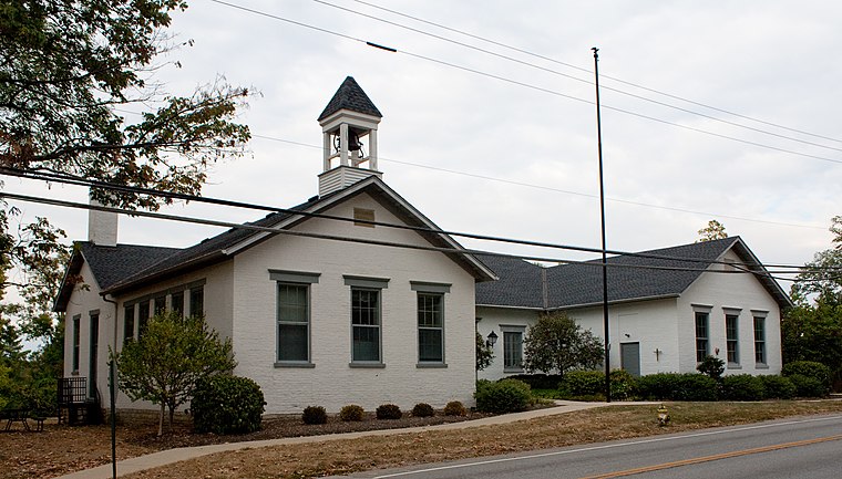
Photo: Greg5030, CC BY-SA 3.0.
The Jefferson Schoolhouse is a historic one-room school in the Village of Indian Hill, Ohio, United States. Built along Drake Road in 1851, it is Indian Hill's oldest extant school. Jefferson Schoolhouse is situated 1½ miles northeast of The Dance Coalition.
Places in the Area
Nearby places include Plainville and Newtown.
Plainville
Hamlet
Plainville is a census-designated place in Columbia Township, Hamilton County, Ohio, United States. The population was 120 at the 2020 census.
Newtown
Village

Photo: Nyttend, Public domain.
Newtown is a village in southeastern Hamilton County, Ohio, United States, near Cincinnati. The population was 2,702 at the 2020 census. Newtown was settled in 1792 and incorporated as a village in 1901.
Fairfax
Village

Photo: Greg5030, CC BY-SA 4.0.
Fairfax is a village in Hamilton County, Ohio, United States. It is a suburb of Cincinnati. The population was 1,768 at the 2020 census.
The Dance Coalition
- Category: building
- Location: Village of Mariemont, Hamilton County, Greater Cincinnati, Ohio, Midwest, United States, North America
- View on OpenStreetMap
Latitude
39.14344° or 39° 8′ 36″ northLongitude
-84.36566° or 84° 21′ 56″ westOpen location code
86FQ4JVM+9POpenStreetMap ID
way 1445785515OpenStreetMap feature
amenity=dancing_schoolOpenStreetMap feature
building=retail
This page is based on OpenStreetMap, Wikidata, and Wikimedia Commons.
We’d love your help improving our open data sources. Thank you for contributing.
Satellite Map
Discover The Dance Coalition from above in high-definition satellite imagery.
Notable Places Nearby
Highlights include Anytime Fitness and Mariemont Branch Library.
Nearby Places
Explore places such as Bank of America and Magic Wok.
Hamilton County: Must-Visit Destinations
Delve into Cincinnati, Loveland, Sharonville, and Springdale.
Curious Retail Buildings to Discover
Uncover intriguing retail buildings from every corner of the globe.
About Mapcarta. Data © OpenStreetMap contributors and available under the Open Database License". Text is available under the CC BY-SA 4.0 license, except for photos, directions, and the map. Photo: Wikimedia, CC0.