Herrmann-Daur-Schule
Herrmann-Daur-Schule is a school in Weil am Rhein, Lörrach, Baden-Württemberg which is located on Teichweg. Herrmann-Daur-Schule is situated nearby to the playground Teichweg, as well as near the community center Altrheinhalle.| Tap on a place to explore it |
Places of Interest Nearby
Highlights include Vitra Design Museum and Three Countries Bridge.
Vitra Design Museum
Museum
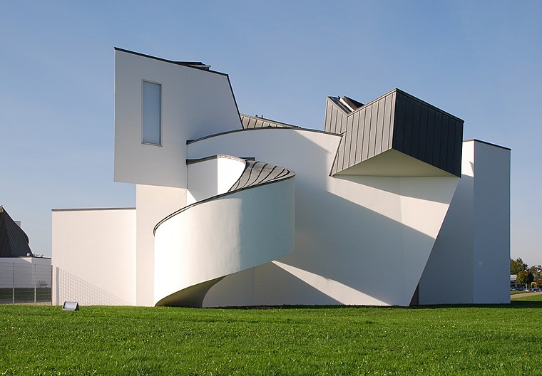
Photo: Taxiarchos228, CC BY-SA 3.0.
The Vitra Design Museum is a privately owned museum for design in Weil am Rhein, Germany. The architect of this building was Frank O. Gehry. His architecture was based on the art movement of the early 20th century, deconstructivism. Vitra Design Museum is situated 3½ km southeast of Herrmann-Daur-Schule.
Three Countries Bridge
Bridge

Photo: Taxiarchos228, CC BY 3.0.
The Three Countries Bridge is an arch bridge which crosses the Rhine between the commune of Huningue and Weil am Rhein, within the Basel metropolitan area. Three Countries Bridge is situated 3½ km south of Herrmann-Daur-Schule.
Eimeldingen railway stop
Railway stop
 Eimeldingen railway stop is situated 1¼ km northeast of Herrmann-Daur-Schule.
Places in the Area
Nearby places include Eimeldingen and Haltingen.
Eimeldingen
Village

Photo: Taxiarchos228, CC BY 3.0.
Eimeldingen is a municipality in the district of Lörrach, in Baden-Württemberg, Germany.
Haltingen
Village

Photo: Taxiarchos228, CC BY 3.0.
Haltingen is a village, which is situated 2½ km east of Herrmann-Daur-Schule.
Ötlingen
Village

Photo: Wikimedia, CC BY-SA 3.0.
Ötlingen is a Stadtteil and Ortschaft of Weil am Rhein, Baden-Württemberg, Germany. It is located on the northwestern foothills of the Tüllinger Berg. Once an independent community, this area was incorporated into Weil am Rhein in 1971. Ötlingen is situated 3 km east of Herrmann-Daur-Schule.
Herrmann-Daur-Schule
- Type: School
- Address: Teichweg 9, Weil am Rhein, 79576
- Categories: building and education
- Location: Weil am Rhein, Lörrach, Freiburg Region, Black Forest, Baden-Württemberg, Germany, Central Europe, Europe
- View on OpenStreetMap
Latitude
47.62305° or 47° 37′ 23″ northLongitude
7.58235° or 7° 34′ 56″ eastOpen location code
8FV9JHFJ+6WOpenStreetMap ID
way 150872032OpenStreetMap feature
amenity=schoolOpenStreetMap feature
building=yes
This page is based on OpenStreetMap, Wikidata, and Wikimedia Commons.
We’d love your help improving our open data sources. Thank you for contributing.
Satellite Map
Discover Herrmann-Daur-Schule from above in high-definition satellite imagery.
Notable Places Nearby
Highlights include Altrheinhalle and Teichweg.
Nearby Places
Explore places such as Evangelischer Kindergarten St. Nikolaus and Gasthaus zur Krone.
Black Forest: Must-Visit Destinations
Delve into Freiburg, Baden-Baden, Pforzheim, and Offenburg.
Curious Schools to Discover
Uncover intriguing schools from every corner of the globe.
About Mapcarta. Data © OpenStreetMap contributors and available under the Open Database License". Text is available under the CC BY-SA 4.0 license, except for photos, directions, and the map. Photo: Joergens.mi, CC BY-SA 3.0.