Albingia
Albingia is a building in Bordeaux, Gironde, Nouvelle-Aquitaine. Albingia is situated nearby to the public building Chambre Régionale de Commerce et d’Industrie d’Aquitaine, as well as near the college ESME Sudria.| Tap on a place to explore it |
Places of Interest Nearby
Highlights include Église orthodoxe grecque de Bordeaux and BETASOM.
Église orthodoxe grecque de Bordeaux
Church

Photo: Peretheodore.bx, CC BY-SA 3.0.
Église orthodoxe grecque de Bordeaux is a church, which is situated 510 metres southeast of Albingia.
BETASOM
Museum
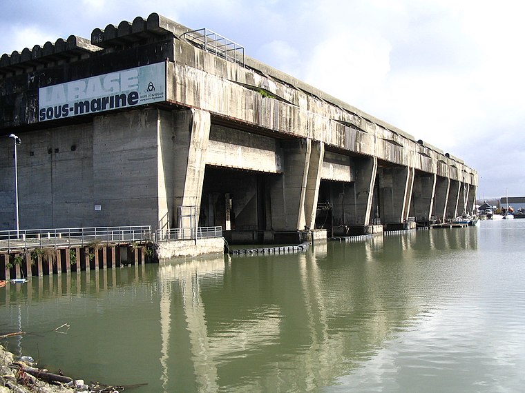
Photo: Wikimedia, CC BY-SA 2.5.
BETASOM was a submarine base established at Bordeaux, France by the Regia Marina during the Second World War. From this base, Italian submarines participated in the Battle of the Atlantic from 1940 to 1943 as part of the Axis anti-shipping campaign against the Allies. BETASOM is situated 1¼ km northeast of Albingia.
Jacques Chaban-Delmas Bridge
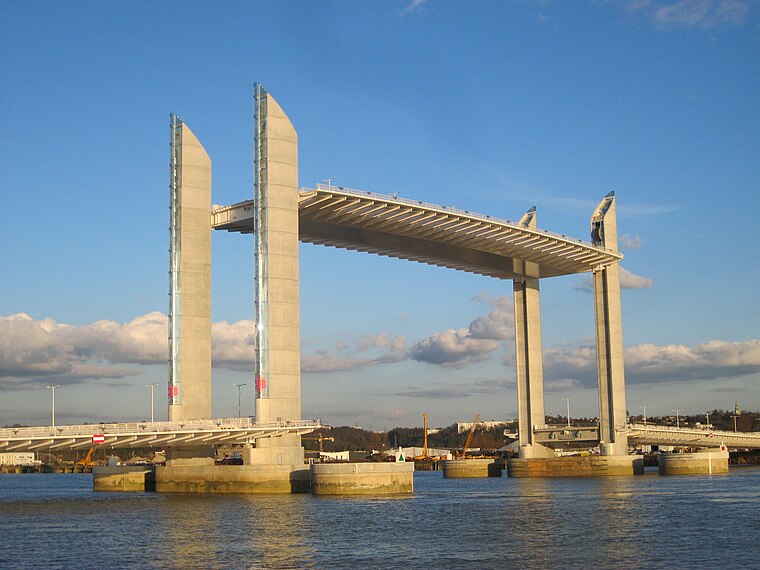
Photo: Prométhée33, CC BY-SA 3.0.
The Pont Jacques Chaban-Delmas is a vertical-lift bridge over the Garonne in Bordeaux, France. It was inaugurated on 16 March 2013 by President François Hollande and Alain Juppé, mayor of Bordeaux. Jacques Chaban-Delmas Bridge is situated 2 km southeast of Albingia.
Places in the Area
Nearby places include Les Aubiers and Le Bouscat.

Le Bouscat
Town

Photo: Dark Attsios, CC BY-SA 3.0.
Le Bouscat is a commune in the Gironde department in Nouvelle-Aquitaine in southwestern France. It is a suburb of the city of Bordeaux and is adjacent to it on the north side. Its sister city is Glen Ellyn, Illinois, USA…
Bordeaux, Port of the Moon
Quarter

Photo: Raptor-kev, Public domain.
The Port de la Lune is the name given to the harbour of Bordeaux, dating to the Middle Ages, because of the shape of the river crossing the city. It is represented by a crescent on the coat of arms of Bordeaux, and by three interlaced crescents in the logotype of the municipality.
Albingia
- Type: Building
- Location: Bordeaux, Arrondissement of Bordeaux, Gironde, Nouvelle-Aquitaine, France, Europe
- View on OpenStreetMap
Latitude
44.86532° or 44° 51′ 55″ northLongitude
-0.57382° or 0° 34′ 26″ westOpen location code
8CPXVC8G+4FOpenStreetMap ID
way 154358464OpenStreetMap feature
building=yes
This page is based on OpenStreetMap, Wikidata, and Wikimedia Commons.
We’d love your help improving our open data sources. Thank you for contributing.
Satellite Map
Discover Albingia from above in high-definition satellite imagery.
Notable Places Nearby
Highlights include Chambre Régionale de Commerce et d’Industrie d’Aquitaine and ESME Sudria.
Nearby Places
Explore places such as Gaz de Bordeaux and ProBTP.
Gironde: Must-Visit Destinations
Delve into Arcachon, Saint-Émilion, Soulac-sur-Mer, and Euronat.
Curious Buildings to Discover
Uncover intriguing buildings from every corner of the globe.
About Mapcarta. Data © OpenStreetMap contributors and available under the Open Database License". Text is available under the CC BY-SA 4.0 license, except for photos, directions, and the map. Photo: Fabien1309, CC BY-SA 2.0 fr.