Schwantelen
Schwantelen is a building in Lungern, Obwalden. Schwantelen is situated nearby to the peak Sädel, as well as near Gütsch.| Tap on a place to explore it |
Places of Interest Nearby
Highlights include Lungern railway station and Höch Gumme.
Lungern railway station
Railway station
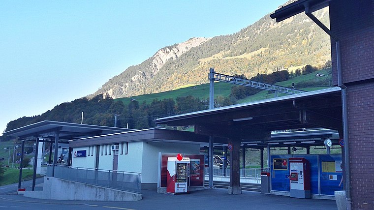 Lungern railway station is a Swiss railway station on the Brünig line, owned by the Zentralbahn, that links Interlaken and Lucerne. The station is located in the municipality of Lungern and the canton of Obwalden. Lungern railway station is situated 3 km southeast of Schwantelen.
Höch Gumme
Peak

Photo: Parpan05, CC BY-SA 3.0.
The Höch Gumme is a mountain of the Emmental Alps in Switzerland. It lies to the east of the Brienzer Rothorn and Arnihaaggen, and the west of the Wilerhorn and Brünig Pass. Höch Gumme is situated 3½ km southwest of Schwantelen.
Glaubenbielen Pass
Mountain saddle

Photo: Wikimedia, CC BY-SA 3.0.
Glaubenbielen Pass is a mountain pass in the Emmental Alps between the Entlebuch region of the canton of Lucerne and the canton of Obwalden. The pass itself is located within Obwalden, and connects Giswil in Obwalden and Sörenberg in the Entlebuch region. Glaubenbielen Pass is situated 3½ km northwest of Schwantelen.
Places in the Area
Nearby places include Obsee and Lungern.

Lungern
Village

Photo: Zuphilip, Copyrighted free use.
Lungern is a municipality in the canton of Obwalden in Switzerland. It encompasses Lake Lungern and, besides the village of Lungern, the settlements of Bürglen, Kaiserstuhl and Obsee. Lungern is situated 2½ km southeast of Schwantelen.
Giswil
Village

Photo: Wikimedia, CC BY-SA 3.0.
Giswil is a municipality in the canton of Obwalden in Switzerland. Giswil is situated 6 km northeast of Schwantelen.
Schwantelen
- Type: Building
- Location: Lungern, Obwalden, Canton of Obwalden, Switzerland, Central Europe, Europe
- View on OpenStreetMap
Latitude
46.8007° or 46° 48′ 3″ northLongitude
8.13394° or 8° 8′ 2″ eastOpen location code
8FRCR42M+7HOpenStreetMap ID
way 154414557OpenStreetMap feature
building=yes
This page is based on OpenStreetMap, Wikidata, and Wikimedia Commons.
We’d love your help improving our open data sources. Thank you for contributing.
Satellite Map
Discover Schwantelen from above in high-definition satellite imagery.
Notable Places Nearby
Highlights include Sädel and Gütsch.
Nearby Places
Explore places such as Sädel and Rieben.
Switzerland: Must-Visit Destinations
Delve into Zurich, Berne, Geneva, and Basel.
Curious Buildings to Discover
Uncover intriguing buildings from every corner of the globe.
About Mapcarta. Data © OpenStreetMap contributors and available under the Open Database License". Text is available under the CC BY-SA 4.0 license, except for photos, directions, and the map. Photo: Simonizer, CC BY-SA 2.0 de.