Blumenpeter’s Kiosk
Blumenpeter’s Kiosk is a kiosk in Grünwald, Munich, Bavaria which is located on Auf der Eierwiese. Blumenpeter’s Kiosk is situated nearby to the health club cor-por-i-sani, as well as near the memorial Kriegerdenkmal.| Tap on a place to explore it |
- Opening hours:
Sunday and Monday: 10:00 AM—7:00 PM
Tuesday—Saturday: 7:00 AM—7:00 PM - Type: Kiosk
- Address: Auf der Eierwiese 1, Grünwald, 82031
- Roof shape: pyramidal
- Wheelchair access: limited
Places of Interest Nearby
Highlights include Kriegerdenkmal and Grünwald municipal library.
Kriegerdenkmal
Memorial

Photo: AHert, CC BY-SA 3.0.
Kriegerdenkmal is a memorial, which is situated 110 metres northeast of Blumenpeter’s Kiosk.
Grünwald municipal library
Library

Photo: Bruno413, CC BY-SA 4.0.
Grünwald municipal library is situated 300 metres northeast of Blumenpeter’s Kiosk.
Grünwald Castle
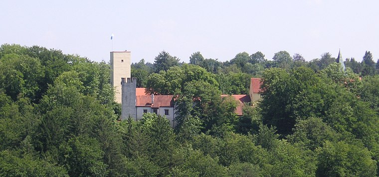
Photo: Wikimedia, CC BY-SA 3.0.
Grünwald Castle is a medieval hill castle in Grünwald, Bavaria. Grünwald Castle is situated 480 metres north of Blumenpeter’s Kiosk.
Places in the Area
Nearby places include Höllriegelskreuth and Grünwald.

Grünwald
Town
Photo: Wikimedia, CC BY-SA 3.0.
Grünwald is a municipality in the district of Munich, in the state of Bavaria, Germany. It is located on the right bank of the Isar, 12 km southwest of Munich.
Blumenpeter’s Kiosk
- Categories: building, shop, and retail building
- Location: Grünwald, Munich, Upper Bavaria, Bavaria, Germany, Central Europe, Europe
- View on OpenStreetMap
Latitude
48.03898° or 48° 2′ 20″ northLongitude
11.52166° or 11° 31′ 18″ eastLevels
1Open location code
8FWH2GQC+HMOpenStreetMap ID
way 156615673OpenStreetMap feature
building=retailOpenStreetMap feature
shop=kioskOpenStreetMap attribute
roof-shape=pyramidalOpenStreetMap attribute
wheelchair=limited
This page is based on OpenStreetMap, Wikidata, and Wikimedia Commons.
We’d love your help improving our open data sources. Thank you for contributing.
Satellite Map
Discover Blumenpeter’s Kiosk from above in high-definition satellite imagery.
Notable Places Nearby
Highlights include cor-por-i-sani and Marienbrunnen.
Nearby Places
Explore places such as Ur-Keltin mit Grünwalder Fibel and Marktplatz/Auf der Eierwiese.
Upper Bavaria: Must-Visit Destinations
Delve into Munich, Ingolstadt, Dachau, and Rosenheim.
Curious Kiosks to Discover
Uncover intriguing kiosks from every corner of the globe.
About Mapcarta. Data © OpenStreetMap contributors and available under the Open Database License". Text is available under the CC BY-SA 4.0 license, except for photos, directions, and the map. Photo: Aconcagua, CC BY-SA 3.0.