Dorfgemeinschaftshaus Birklar
Dorfgemeinschaftshaus Birklar is a community center in Lich, Giessen, Hesse which is located on Mittelstraße. Dorfgemeinschaftshaus Birklar is situated nearby to the fire station Freiwillige Feuerwehr Birklar, as well as near the cemetery Friedhof Birklar.| Tap on a place to explore it |
Places of Interest Nearby
Highlights include Evangelische Kirche Birklar and Lindenberg bei Birklar.
Evangelische Kirche Birklar
Church

Photo: Cherubino, CC BY-SA 3.0.
Evangelische Kirche Birklar is a church, which is situated 170 metres southwest of Dorfgemeinschaftshaus Birklar.
Lindenberg bei Birklar
Nature reserve

Photo: Cherubino, CC BY-SA 4.0.
Lindenberg bei Birklar is a nature reserve.
Arnsburg Abbey
Monastery
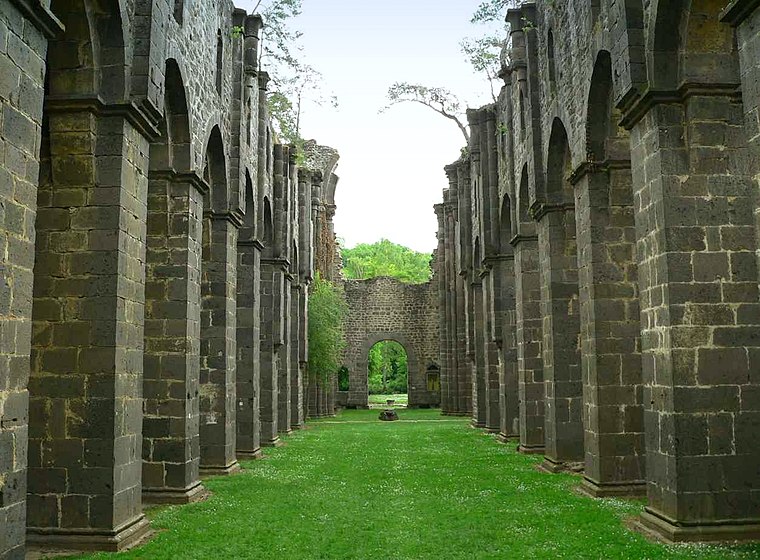
Photo: Presse03, CC BY-SA 3.0.
Arnsburg Abbey is a former Cistercian monastery near Lich in the Wetterau, Hesse, Germany. It was founded by monks from Eberbach Abbey in 1174. Although heavily damaged in the Thirty Years' War it was rebuilt later in the 17th century and prospered in the 18th century, when much of the abbey was rebuilt in Baroque style. Arnsburg Abbey is situated 1½ km west of Dorfgemeinschaftshaus Birklar.
Places in the Area
Nearby places include Holzheim and Steinheim.
Holzheim
Village
 Holzheim is a village, which is situated 7 km west of Dorfgemeinschaftshaus Birklar.
Steinheim
Village

Photo: Cherubino, CC BY-SA 3.0.
Steinheim is a village, which is situated 10 km southeast of Dorfgemeinschaftshaus Birklar.
Dorfgemeinschaftshaus Birklar
- Type: Community center
- Address: Mittelstraße 24, Birklar, Lich, 35423
- Categories: building and public building
- Location: Lich, Giessen, North Hesse, Hesse, Germany, Central Europe, Europe
- View on OpenStreetMap
Latitude
50.49579° or 50° 29′ 45″ northLongitude
8.81406° or 8° 48′ 51″ eastOpen location code
9F2CFRW7+8JOpenStreetMap ID
way 166822229OpenStreetMap feature
amenity=community_centreOpenStreetMap feature
building=public
This page is based on OpenStreetMap, Wikidata, and Wikimedia Commons.
We’d love your help improving our open data sources. Thank you for contributing.
Satellite Map
Discover Dorfgemeinschaftshaus Birklar from above in high-definition satellite imagery.
Notable Places Nearby
Highlights include Freiwillige Feuerwehr Birklar and Friedhof Birklar.
Nearby Places
Explore places such as Neue Licher Pforte and Pizzeria La Dolce Vita.
North Hesse: Must-Visit Destinations
Delve into Kassel, Wetzlar, Marburg, and Fulda.
Curious Community Centers to Discover
Uncover intriguing community centers from every corner of the globe.
About Mapcarta. Data © OpenStreetMap contributors and available under the Open Database License". Text is available under the CC BY-SA 4.0 license, except for photos, directions, and the map. Photo: Kreuzschnabel, CC BY-SA 3.0.