EVS Wertstoffhof Saarlouis
EVS Wertstoffhof Saarlouis is in Saarlouis, Saarland, and is located on Fasanenallee. EVS Wertstoffhof Saarlouis is situated nearby to the church Saints Peter and Paul, as well as near the barracks Graf-Werder-Kaserne.| Tap on a place to explore it |
- Opening hours: Tuesday—Saturday 9:00 AM—12:30 PM, 1:00 PM—4:45 PM, and Saturday 9:00 AM—2:15 PM
- Type: Industry
- Address: Fasanenallee 52, Saarlouis, 66740
Places of Interest Nearby
Highlights include Saints Peter and Paul and Katerturm.
Saints Peter and Paul
Church

Photo: LoKiLeCh, CC BY-SA 3.0.
Saints Peter and Paul is a church, which is situated 520 metres west of EVS Wertstoffhof Saarlouis.
Katerturm

Photo: Xocolatl, Public domain.
Katerturm is situated 1 km east of EVS Wertstoffhof Saarlouis.
Haus Ludwig
Museum
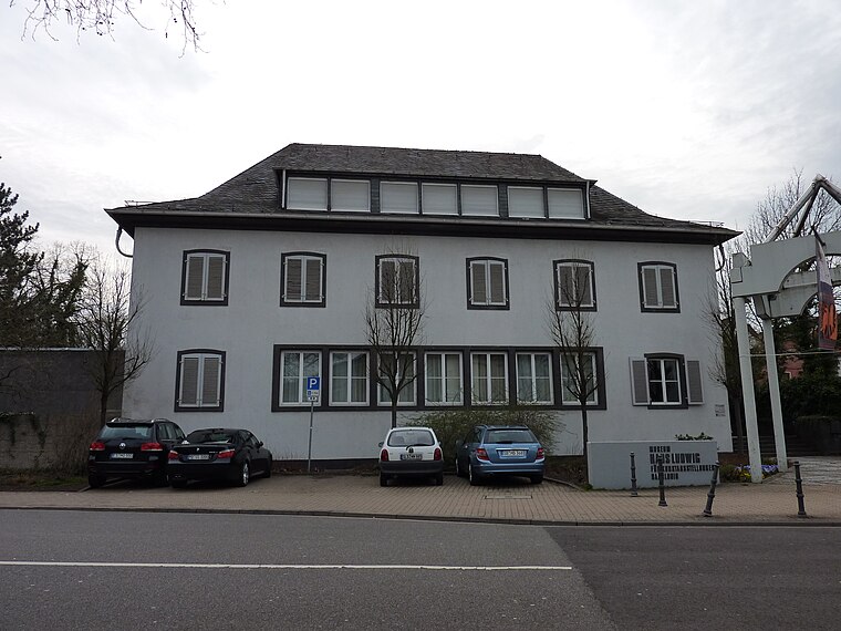
Photo: Xocolatl, Public domain.
Haus Ludwig, formerly Galerie Ludwig, is an art museum in Saarland, Germany. Haus Ludwig is situated 1¼ km east of EVS Wertstoffhof Saarlouis.
Places in the Area
Nearby places include Beaumarais and Wallerfangen.

Wallerfangen
Village

Photo: Kolling, CC BY-SA 3.0.
Wallerfangen is a municipality of Saarlouis district, Saarland, Germany. Located west of Saarlouis and along the French border, it is the seat of the villages of Ittersdorf, Ihn, Leidingen, St.
Neuforweiler
Village

Photo: Kolling, CC BY-SA 3.0.
Neuforweiler is a village, which is situated 3½ km south of EVS Wertstoffhof Saarlouis.
EVS Wertstoffhof Saarlouis
- Location: Saarlouis, Saarlouis, Saarland, Germany, Central Europe, Europe
- View on OpenStreetMap
Latitude
49.31689° or 49° 19′ 1″ northLongitude
6.73171° or 6° 43′ 54″ eastOperator
Entsorgungsverband SaarOpen location code
8FX88P8J+QMOpenStreetMap ID
way 167199583OpenStreetMap feature
amenity=recyclingOpenStreetMap feature
landuse=industrial
This page is based on OpenStreetMap, Wikidata, and Wikimedia Commons.
We’d love your help improving our open data sources. Thank you for contributing.
Satellite Map
Discover EVS Wertstoffhof Saarlouis from above in high-definition satellite imagery.
Notable Places Nearby
Highlights include Graf-Werder-Kaserne and Bigots Schlösschen.
Nearby Places
Explore places such as Checkpoint EFI and Bartruff.
Saarland: Must-Visit Destinations
Delve into Saarbrücken, Homburg, Merzig, and Neunkirchen.
Curious Places to Discover
Uncover intriguing places from every corner of the globe.
About Mapcarta. Data © OpenStreetMap contributors and available under the Open Database License". Text is available under the CC BY-SA 4.0 license, except for photos, directions, and the map. Photo: wolfgangstaudt, CC BY 2.0.