WH5887
WH5887 is a bunker in Haut-Rhin, Grand Est. WH5887 is situated nearby to the sports venue Parcours Santé, as well as near the playground Aire de Pique-Nique, de Jeux et de Pétanque du Rhin.| Tap on a place to explore it |
Places of Interest Nearby
Highlights include Vitra Design Museum and Three Countries Bridge.
Vitra Design Museum
Museum
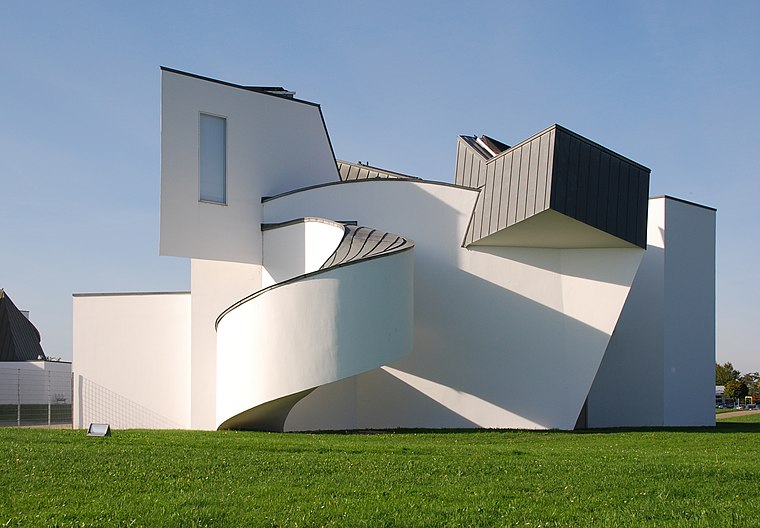
Photo: Taxiarchos228, CC BY-SA 3.0.
The Vitra Design Museum is a privately owned museum for design in Weil am Rhein, Germany. The architect of this building was Frank O. Gehry. His architecture was based on the art movement of the early 20th century, deconstructivism. Vitra Design Museum is situated 4 km southeast of WH5887.
Three Countries Bridge
Bridge

Photo: Taxiarchos228, CC BY 3.0.
The Three Countries Bridge is an arch bridge which crosses the Rhine between the commune of Huningue and Weil am Rhein, within the Basel metropolitan area. Three Countries Bridge is situated 3 km south of WH5887.
Église Saint-Nicolas de Village-Neuf
Church

Photo: Rauenstein, CC BY-SA 3.0.
Église Saint-Nicolas de Village-Neuf is a church, which is situated 1½ km south of WH5887.
Places in the Area
Nearby places include Eimeldingen and Haltingen.
Eimeldingen
Village

Photo: Taxiarchos228, CC BY 3.0.
Eimeldingen is a municipality in the district of Lörrach, in Baden-Württemberg, Germany.
Haltingen
Village

Photo: Taxiarchos228, CC BY 3.0.
Haltingen is a village, which is situated 3 km east of WH5887.
Saint-Louis

Photo: Comstagiaire SL, CC BY-SA 4.0.
Saint-Louis is a city of 23,000 people in Alsace in the Grand-Est at the German and Swiss borders, just north of Basel. Saint-Louis is rich in cultural resources and fun activities.
WH5887
- Type: Bunker
- Categories: building, historic site, and military installation
- Location: Haut-Rhin, Grand Est, France, Europe
- View on OpenStreetMap
Latitude
47.61779° or 47° 37′ 4″ northLongitude
7.57463° or 7° 34′ 29″ eastOpen location code
8FV9JH9F+4VOpenStreetMap ID
way 174645475OpenStreetMap feature
building=yesOpenStreetMap feature
historic=yesOpenStreetMap feature
military=bunker
This page is based on OpenStreetMap, Wikidata, and Wikimedia Commons.
We’d love your help improving our open data sources. Thank you for contributing.
Satellite Map
Discover WH5887 from above in high-definition satellite imagery.
Notable Places Nearby
Highlights include Parcours Santé and Aire de Pique-Nique, de Jeux et de Pétanque du Rhin.
Nearby Places
Explore places such as Am Stauwehr and Stauwehr Märkt.
Grand Est: Must-Visit Destinations
Delve into Strasbourg, Reims, Metz, and Nancy.
Curious Bunkers to Discover
Uncover intriguing bunkers from every corner of the globe.
About Mapcarta. Data © OpenStreetMap contributors and available under the Open Database License". Text is available under the CC BY-SA 4.0 license, except for photos, directions, and the map. Photo: Wernain Samuel, CC BY-SA 3.0.