Centre médical de la Base navale
Centre médical de la Base navale is a building in Brest, Finistère, Brittany. Centre médical de la Base navale is situated nearby to the pier Ponton FREMM, as well as near the bunker Submarine base of Brest.| Tap on a place to explore it |
Places of Interest Nearby
Highlights include Submarine base of Brest and Portzic Lighthouse.
Submarine base of Brest
Bunker
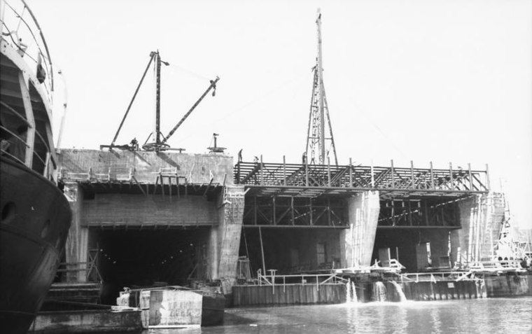
Photo: Wikimedia, CC BY-SA 3.0 de.
Submarine base of Brest is a bunker, which is situated 390 metres southwest of Centre médical de la Base navale.
Portzic Lighthouse
Lighthouse

Photo: Pline, CC BY-SA 3.0.
The Portzic Lighthouse is situated on the north-eastern extremity of the Goulet de Brest and is the nearest lighthouse to the town of Brest. It is a 35 metres tall octagonal tower. Portzic Lighthouse is situated 1½ km southwest of Centre médical de la Base navale.
Fort de Portzic
Fort

Photo: Llorenzi, CC BY-SA 3.0.
The Fort de Portzic was built near the town of Brest by Vauban between 1693 and 1699 as part of the defences of the goulet de Brest. It faces the pointe des Espagnols and was improved and enlarged over time, since it formed the town's last and innermost defence. Fort de Portzic is situated 2 km southwest of Centre médical de la Base navale.
Places in the Area
Nearby places include Saint-Pierre-Quilbignon and Porte Caffarelli.
Saint-Pierre-Quilbignon
Suburb

Photo: Wikimedia, Public domain.
Saint-Pierre-Quilbignon is a suburb.


Centre médical de la Base navale
- Type: Building
- Location: Brest, Arrondissement de Brest, Finistère, Brittany, France, Europe
- View on OpenStreetMap
Latitude
48.36926° or 48° 22′ 9″ northLongitude
-4.5183° or 4° 31′ 6″ westOpen location code
8CWQ9F9J+PMOpenStreetMap ID
way 185343872OpenStreetMap feature
building=yes
This page is based on OpenStreetMap, Wikidata, and Wikimedia Commons.
We’d love your help improving our open data sources. Thank you for contributing.
Satellite Map
Discover Centre médical de la Base navale from above in high-definition satellite imagery.
Notable Places Nearby
Highlights include Ponton FREMM and Centre Roland Morillot.
Nearby Places
Explore places such as Foyer de Laninon and Poste A/B.
Brittany: Must-Visit Destinations
Delve into Rennes, Finistère, Ille-et-Vilaine, and Morbihan.
Curious Buildings to Discover
Uncover intriguing buildings from every corner of the globe.
About Mapcarta. Data © OpenStreetMap contributors and available under the Open Database License". Text is available under the CC BY-SA 4.0 license, except for photos, directions, and the map. Photo: Inkey, CC BY-SA 2.5.