Cholerabrunnen
Cholerabrunnen is a work of art in Dresden, Saxon Elbland, Saxony. Cholerabrunnen is situated nearby to the museum TimeRide VR, as well as near the art gallery Walentowski Galerien.| Tap on a place to explore it |
Photo: Wikimedia, CC BY-SA 4.0.
Places of Interest Nearby
Highlights include Gemäldegalerie Alte Meister and Semperoper.
Gemäldegalerie Alte Meister
Museum

Photo: Wikimedia, Public domain.
The Gemäldegalerie Alte Meister in Dresden, Germany, displays around 750 paintings from the 15th to the 18th centuries. It includes major Italian Renaissance works as well as Dutch and Flemish paintings. Gemäldegalerie Alte Meister is situated 180 metres north of Cholerabrunnen.
Semperoper
Theater building
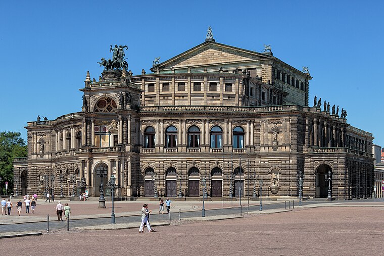
Photo: Avda, CC BY-SA 3.0.
The Semperoper is the opera house of the Sächsische Staatsoper Dresden and the concert hall of the Staatskapelle Dresden. It is also home to the Semperoper Ballett. Semperoper is situated 300 metres north of Cholerabrunnen.
Zwinger
Park

Photo: Immanuel Giel, CC BY-SA 3.0.
The Zwinger is a palatial complex with gardens in Dresden, Germany. Designed by architect Matthäus Daniel Pöppelmann, it is one of the most important buildings of the Baroque period in Germany. Zwinger is situated 250 metres northwest of Cholerabrunnen.
Places in the Area
Nearby places include Innere Altstadt and Wilsdruffer Vorstadt.


Innere Neustadt
Suburb

Photo: Wikimedia, CC BY-SA 4.0.
The Innere Neustadt is a neighborhood in Dresden within the administrative district of Neustadt. The name is derived from "Neue Königliche Stadt", the name given to the former district of Altendresden when it was rebuilt after a fire before 1732.
Cholerabrunnen
- Type: Work of art
- Description: water well
- Categories: water well, body of water, tourism, and fountain
- Location: Dresden, Saxon Elbland, Saxony, Germany, Central Europe, Europe
- View on OpenStreetMap
Latitude
51.05182° or 51° 3′ 7″ northLongitude
13.73475° or 13° 44′ 5″ eastInception
1846Open location code
9F3M3P2M+PVOpenStreetMap ID
way 192355383OpenStreetMap feature
amenity=fountainOpenStreetMap feature
natural=waterOpenStreetMap feature
tourism=artworkWikidata ID
Q1075896
This page is based on OpenStreetMap, Wikidata, and Wikimedia Commons.
We’d love your help improving our open data sources. Thank you for contributing.
Satellite Map
Discover Cholerabrunnen from above in high-definition satellite imagery.
In Other Languages
From Belarusian to German—“Cholerabrunnen” goes by many names.
- Belarusian: “Халерны слуп”
- German: “Cholera-Brunnen”
- German: “Cholerabrunnen”
- German: “Gutschmid-Brunnen”
Notable Places Nearby
Highlights include TimeRide VR and Dresden Porcelain Collection.
Nearby Places
Explore places such as Sophienkeller im Taschenbergpalais and CÔDÔ.
Saxon Elbland: Must-Visit Destinations
Delve into Meißen, Riesa, Radebeul, and Freital.
Curious Work Of Arts to Discover
Uncover intriguing work of arts from every corner of the globe.
About Mapcarta. Data © OpenStreetMap contributors and available under the Open Database License". Text is available under the CC BY-SA 4.0 license, except for photos, directions, and the map. Photo: Wikimedia, CC BY-SA 4.0.