Stubnerkogelbahn Mittelstation
Stubnerkogelbahn Mittelstation is an aerial lift in Bad Gastein, St. Johann im Pongau District, Salzburg which is located on Stubnerkogel and has an elevation of 1,796 metres. Stubnerkogelbahn Mittelstation is situated nearby to Mitterwirth Alpe, as well as near the grassland Zitterauer Alpe.| Tap on a place to explore it |
- Type: Aerial lift
- Address: Stubnerkogel 3, Bad Gastein, 5645
- Wheelchair access: yes
Places of Interest Nearby
Highlights include Stubnerkogel and Bad Gastein railway station.

Bad Gastein railway station
Railway station
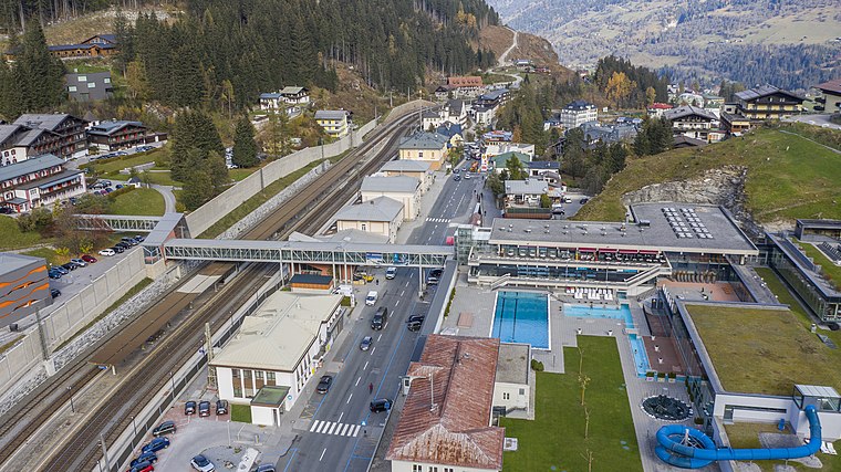
Photo: Wikimedia, CC BY-SA 3.0 de.
Bad Gastein railway station is situated 1½ km east of Stubnerkogelbahn Mittelstation.

Places in the Area
Nearby places include Böckstein and Badbruck.

Badbruck
Hamlet

Photo: Herzi Pinki, CC BY-SA 4.0.
Badbruck is a hamlet, which is situated 3 km northeast of Stubnerkogelbahn Mittelstation.
Kötschachdorf
Hamlet

Photo: Man77, CC BY-SA 4.0.
Kötschachdorf is a hamlet, which is situated 3 km northeast of Stubnerkogelbahn Mittelstation.
Stubnerkogelbahn Mittelstation
- Categories: building, station, and transportation
- Location: Bad Gastein, St. Johann im Pongau District, Salzburg, Austria, Central Europe, Europe
- View on OpenStreetMap
Latitude
47.1114° or 47° 6′ 41″ northLongitude
13.11217° or 13° 6′ 44″ eastElevation
1,796 metres (5,892 feet)Open location code
8FVM4466+HVOpenStreetMap ID
way 192626716OpenStreetMap feature
aerialway=stationOpenStreetMap feature
building=yesOpenStreetMap feature
public_transport=stationOpenStreetMap attribute
wheelchair=yes
This page is based on OpenStreetMap, Wikidata, and Wikimedia Commons.
We’d love your help improving our open data sources. Thank you for contributing.
Satellite Map
Discover Stubnerkogelbahn Mittelstation from above in high-definition satellite imagery.
Notable Places Nearby
Highlights include Mitterwirth Alpe and Zitterauer Alpe.
Nearby Places
Explore places such as Salesenhütte and Ahornhütte.
Salzburg: Must-Visit Destinations
Delve into Salzburg, Bischofshofen, Zell am See, and St. Johann im Pongau.
Curious Aerial Lifts to Discover
Uncover intriguing aerial lifts from every corner of the globe.
About Mapcarta. Data © OpenStreetMap contributors and available under the Open Database License". Text is available under the CC BY-SA 4.0 license, except for photos, directions, and the map. Photo: Usien, CC BY-SA 4.0.