Centre de Santé
Centre de Santé is a doctor’s office in Centre Region, Cameroon. Centre de Santé is situated nearby to the public building Château d’Eau de Mimboman, as well as near the church Sœurs Notre-Dame.| Tap on a place to explore it |
Places of Interest Nearby
Highlights include Ahmadou Ahidjo Stadium and Yaoundé train station.
Ahmadou Ahidjo Stadium
Stadium

Photo: Kondah, CC BY-SA 4.0.
Ahmadou Ahidjo Stadium is a multi-purpose stadium in Yaoundé, Cameroon. It is used mostly for football matches and it also has athletics facilities. It was built in 1972. Ahmadou Ahidjo Stadium is situated 2½ km northwest of Centre de Santé.
Yaoundé train station
Railway station

Photo: Frankywilly, CC BY-SA 4.0.
Yaoundé train station is a railway station, which is situated 3 km west of Centre de Santé.
Blackitude Museum
Museum
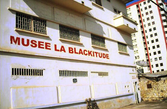
Photo: Awinda, CC BY-SA 3.0.
The Blackitude Museum is a private ethnographic institution. It is located in the city center of Yaoundé behind the Presidential Tribune on the Boulevard du 20 Mai, in the Central Region of Cameroon. Blackitude Museum is situated 4 km west of Centre de Santé.
Places in the Area
Nearby places include Yaoundé.
Yaoundé

Photo: Bdx, CC BY-SA 4.0.
Yaoundé is the capital of Cameroon, and the country's second most populous city. It is smaller than the economic centre, but still a bustling city. Called the city on seven hills, Yaoundé is home to people from all over Cameroon.
Centre de Santé
- Type: Doctor’s office
- Categories: health care and building
- Location: Centre Region, Cameroon, Central Africa, Africa
- View on OpenStreetMap
Latitude
3.86877° or 3° 52′ 8″ northLongitude
11.55317° or 11° 33′ 11″ eastOpen location code
6FMHVH93+G7OpenStreetMap ID
way 192833008OpenStreetMap feature
amenity=doctorsOpenStreetMap feature
building=yesOpenStreetMap feature
healthcare=doctor
This page is based on OpenStreetMap, Wikidata, and Wikimedia Commons.
We’d love your help improving our open data sources. Thank you for contributing.
Satellite Map
Discover Centre de Santé from above in high-definition satellite imagery.
Places with the Same Name
Discover other places named “Centre de Santé”.
Notable Places Nearby
Highlights include Château d’Eau de Mimboman and Sœurs Notre-Dame.
Nearby Places
Explore places such as Pharmacie Aumachae and Ebenezer.
Cameroon: Must-Visit Destinations
Delve into Yaoundé, Douala, Adamaoua, and Mount Cameroon.
Curious Doctor’s Offices to Discover
Uncover intriguing doctor’s offices from every corner of the globe.
About Mapcarta. Data © OpenStreetMap contributors and available under the Open Database License". Text is available under the CC BY-SA 4.0 license, except for photos, directions, and the map. Photo: Jjtkk, CC BY-SA 3.0.