Stade du Pousset
Stade du Pousset is a pitch in Hyères, Arrondissement of Toulon, Provence-Alpes-Côte d’Azur. Stade du Pousset is situated nearby to the protected area Marais du Pousset, as well as near the swimming pool Pataugeoire.| Tap on a place to explore it |
Places of Interest Nearby
Highlights include Église St Pierre (Hyères) and La Tour Fondue, Hyères.
Église St Pierre (Hyères)
Church

Photo: Hyerestourisme, CC BY-SA 3.0.
Église St Pierre (Hyères) is a church, which is situated 1¼ km southwest of Stade du Pousset.
La Tour Fondue, Hyères
Fort
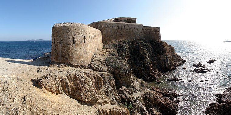
Photo: Kuebi, CC BY-SA 3.0.
La Tour Fondue, Hyères is a fort, which is situated 2 km southeast of Stade du Pousset.
Phare du Grand-Ribaud
Building

Photo: CaptainHaddock, CC BY-SA 3.0.
Phare du Grand-Ribaud is a building, which is situated 3 km south of Stade du Pousset.
Places in the Area
Nearby places include La Capte.

Stade du Pousset
- Type: Pitch
- Categories: sports venue, recreation area, football, and sports location
- Location: Hyères, Arrondissement of Toulon, Var, Provence-Alpes-Côte d’Azur, France, Europe
- View on OpenStreetMap
Latitude
43.04372° or 43° 2′ 37″ northLongitude
6.14413° or 6° 8′ 39″ eastOpen location code
8FM824VV+FMOpenStreetMap ID
way 197934801OpenStreetMap feature
leisure=pitchOpenStreetMap feature
sport=soccerWikidata ID
Q120167208
This page is based on OpenStreetMap, Wikidata, and Wikimedia Commons.
We’d love your help improving our open data sources. Thank you for contributing.
Satellite Map
Discover Stade du Pousset from above in high-definition satellite imagery.
In Other Languages
“Stade du Pousset” goes by many names.
- French: “stade du Pousset”
- French: “Stade du Pousset”
Notable Places Nearby
Highlights include Marais du Pousset and Pataugeoire.
Nearby Places
Explore places such as Pousset and Laverie.
Var: Must-Visit Destinations
Delve into Toulon, Saint-Tropez, Fréjus, and Saint-Raphaël.
Curious Pitches to Discover
Uncover intriguing pitches from every corner of the globe.
About Mapcarta. Data © OpenStreetMap contributors and available under the Open Database License". Text is available under the CC BY-SA 4.0 license, except for photos, directions, and the map. Photo: ComputerHotline, CC BY 3.0.