Saint John the Apostle and Evangelist
Saint John the Apostle and Evangelist is a church in St. Louis, St. Louis Area, Missouri which is located on Plaza Square. Saint John the Apostle and Evangelist is situated nearby to Centenary Methodist Episcopal Church, as well as near Eternal Flame Park.| Tap on a place to explore it |
- Type: Church
- Denomination: Roman Catholic
- Also known as: “St. Johns”
- Address: 15 Plaza Square, Saint Louis, MO 63103
- Wheelchair access: limited
Places of Interest Nearby
Highlights include Enterprise Center and Centenary Methodist Episcopal Church.
Enterprise Center
Stadium
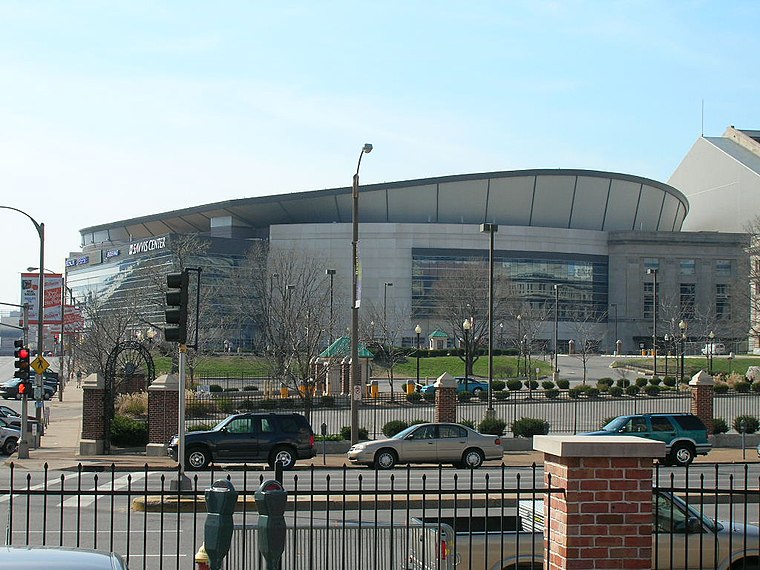
Photo: Haaron755, CC BY-SA 3.0.
Enterprise Center is an 18,096-seat arena located in downtown St. Louis, Missouri, United States. Its primary tenant is the St. Louis Blues of the National Hockey League, but it is also used for other functions, such as NCAA basketball, NCAA hockey, concerts, professional wrestling and more. Enterprise Center is situated 990 feet south of Saint John the Apostle and Evangelist.
Centenary Methodist Episcopal Church
Church

Photo: Mx. Granger, CC0.
The Centenary Methodist Episcopal Church, South in St. Louis, Missouri is a Gothic Revival church that was built in 1869. It was listed on the National Register of Historic Places in 1997. Centenary Methodist Episcopal Church is situated 390 feet northwest of Saint John the Apostle and Evangelist.
Stifel Theatre
Theater building
The Stifel Theatre is a civic performing arts building located in St. Louis, Missouri. Stifel Theatre is situated 790 feet southeast of Saint John the Apostle and Evangelist.
Places in the Area
Nearby places include Downtown West and Carr Square.
Downtown West
Neighborhood
Downtown West is a neighborhood in St. Louis, Missouri. It is, as the name suggests, a section of downtown that is further inland, west from the banks of the Mississippi River.
Carr Square
Neighborhood

Photo: Paul Sableman, CC BY 2.0.
Carr Square is a neighborhood of St. Louis, Missouri. The neighborhood is bounded by Cass Avenue on the north, Carr Street on the south, North Tucker Boulevard and North 13th Street on the east, and North Jefferson on the west.
Downtown St. Louis
Neighborhood
 Downtown St. Louis is the central business district of St. Louis, Missouri, the hub of tourism and entertainment, and the anchor of the St. Louis metropolitan area.
Saint John the Apostle and Evangelist
- Categories: building, place of worship, and religion
- Location: St. Louis, St. Louis Area, Missouri, Midwest, United States, North America
- View on OpenStreetMap
Latitude
38.62949° or 38° 37′ 46″ northLongitude
-90.20312° or 90° 12′ 11″ westOpen location code
86CFJQHW+QQOpenStreetMap ID
way 201971942OpenStreetMap feature
amenity=place_of_worshipOpenStreetMap feature
building=churchOpenStreetMap attribute
denomination=roman_catholicOpenStreetMap attribute
wheelchair=limited
This page is based on OpenStreetMap, Wikidata, and Wikimedia Commons.
We’d love your help improving our open data sources. Thank you for contributing.
Satellite Map
Discover Saint John the Apostle and Evangelist from above in high-definition satellite imagery.
Places with the Same Name
Discover other places named “Saint John the Apostle and Evangelist”.
Notable Places Nearby
Highlights include Eternal Flame Park and City of St. Louis Department of Health.
Nearby Places
Explore places such as Celtic Cross Monument and City Parc @ Pine.
St. Louis Area: Must-Visit Destinations
Delve into Ferguson, St. Charles, and St. Louis County.
Curious Churches to Discover
Uncover intriguing churches from every corner of the globe.
About Mapcarta. Data © OpenStreetMap contributors and available under the Open Database License". Text is available under the CC BY-SA 4.0 license, except for photos, directions, and the map. Photo: pdsphil, CC BY-SA 2.0.