Antiga Junta de Freguesia de Madaíl
Antiga Junta de Freguesia de Madaíl is a building in O. Azeméis, Riba-Ul, Ul, Macinhata da Seixa, Madail, Oliveira de Azeméis Municipality, Aveiro District. Antiga Junta de Freguesia de Madaíl is situated nearby to the cemetery Cemitério de Madail, as well as near the park Jardim de Madail.| Tap on a place to explore it |
Places of Interest Nearby
Highlights include Oliveira de Azeméis railway station and Câmara Municipal de Oliveira de Azeméis.
Oliveira de Azeméis railway station
Railway station

Photo: JP Ribeiro, CC BY-SA 4.0.
Oliveira de Azeméis railway station is situated 1½ km east of Antiga Junta de Freguesia de Madaíl.
Câmara Municipal de Oliveira de Azeméis
Town hall
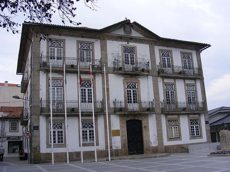
Photo: Piquito, Public domain.
Câmara Municipal de Oliveira de Azeméis is a town hall, which is situated 2 km east of Antiga Junta de Freguesia de Madaíl.
Santiago de Riba - Ul railway halt
Railway stop

Photo: Wikimedia, Public domain.
Santiago de Riba - Ul railway halt is a railway stop, which is situated 2 km northeast of Antiga Junta de Freguesia de Madaíl.
Places in the Area
Nearby places include Ul (Oliveira de Azeméis) and Travanca.
Ul (Oliveira de Azeméis)
Village

Photo: Vitor Oliveira, CC BY-SA 2.0.
Oliveira de Azeméis, Santiago de Riba-Ul, Ul, Macinhata da Seixa e Madail is a civil parish in the municipality of Oliveira de Azeméis in Porto Metropolitan Area, Portugal.
Travanca
Village

Photo: Wikimedia, CC BY-SA 4.0.
Travanca is a village, which is situated 3 km southeast of Antiga Junta de Freguesia de Madaíl.
Vila de Cucujães
Town

Photo: A14843, CC BY-SA 3.0.
Vila de Cucujães is a town, which is situated 4 km north of Antiga Junta de Freguesia de Madaíl.
Antiga Junta de Freguesia de Madaíl
Latitude
40.83652° or 40° 50′ 12″ northLongitude
-8.50055° or 8° 30′ 2″ westOpen location code
8CGHRFPX+JQOpenStreetMap ID
way 203593695OpenStreetMap feature
building=yes
This page is based on OpenStreetMap, Wikidata, and Wikimedia Commons.
We’d love your help improving our open data sources. Thank you for contributing.
Satellite Map
Discover Antiga Junta de Freguesia de Madaíl from above in high-definition satellite imagery.
Notable Places Nearby
Highlights include Cemitério de Madail and Jardim de Madail.
Nearby Places
Explore places such as Cruzeiro de Madaíl and Cruzeiro da Igreja paroquial São Mamede.
Portugal: Must-Visit Destinations
Delve into Lisbon, Caldas da Rainha, Porto, and Coimbra.
Curious Buildings to Discover
Uncover intriguing buildings from every corner of the globe.
About Mapcarta. Data © OpenStreetMap contributors and available under the Open Database License". Text is available under the CC BY-SA 4.0 license, except for photos, directions, and the map. Photo: Tsy1980, CC BY-SA 4.0.