OS Mabruck
OS Mabruck is a building in Osnabrück, Western Plains, Lower Saxony which is located on Bramscher Straße. OS Mabruck is situated nearby to the sports venue Shaolin Center, as well as near Shuyukan Karate Dojo.| Tap on a place to explore it |
Places of Interest Nearby
Highlights include Osnabrück Town Hall and Bürgerpark.
Osnabrück Town Hall
Town hall
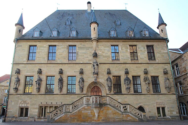
Photo: LigaDue, CC BY-SA 4.0.
The Town Hall of Osnabrück, Germany, was built in the late Gothic style from 1487 to 1512. It is one of Osnabrück's most important buildings and emblems and continues to be used as the city's town hall today. Osnabrück Town Hall is situated 1 km south of OS Mabruck.
Bürgerpark
Park

Photo: Corradox, CC BY-SA 3.0.
Bürgerpark is situated 450 metres northeast of OS Mabruck.
St. Peter’s Cathedral
Church

Photo: Tebdi, CC BY-SA 3.0.
St. Peter's Cathedral in Osnabrück, Germany is the cathedral of the Roman Catholic Diocese of Osnabrück. The cathedral is a late Romanesque building and dominates the city's skyline. St. Peter’s Cathedral is situated 1 km south of OS Mabruck.
Places in the Area
Nearby places include Heger-Tor-Viertel and Sonnenhügel.
Heger-Tor-Viertel
Neighborhood

Photo: Timformatiker, CC BY-SA 4.0.
Heger-Tor-Viertel is a neighborhood.
Sonnenhügel
Suburb
Sonnenhügel is a district of Osnabrück, Germany, located over the northern border of the Innenstadt district.
Innenstadt
Suburb
The Innenstadt is the central district of the city of Osnabrück in Lower Saxony, Germany; its population is roughly 8,300. The Innenstadt comprises the medieval Altstadt and Neustadt, which were united in 1306.
OS Mabruck
- Type: Catering
- Address: Bramscher Straße 33, Osnabrück, 49088
- Categories: building and workshop
- Location: Osnabrück, Western Plains, Lower Saxony, Germany, Central Europe, Europe
- View on OpenStreetMap
Latitude
52.28479° or 52° 17′ 5″ northLongitude
8.04219° or 8° 2′ 32″ eastLevels
2Operator
Maan MouslliOpen location code
9F4C72MR+WVOpenStreetMap ID
way 204320224OpenStreetMap feature
building=yesOpenStreetMap feature
craft=caterer
This page is based on OpenStreetMap, Wikidata, and Wikimedia Commons.
We’d love your help improving our open data sources. Thank you for contributing.
Satellite Map
Discover OS Mabruck from above in high-definition satellite imagery.
Notable Places Nearby
Highlights include Shaolin Center and Shuyukan Karate Dojo.
Nearby Places
Explore places such as Änderungsschneiderei Ser-Hat and Fahrrad-Doc.
Western Plains: Must-Visit Destinations
Delve into Oldenburg, Delmenhorst, Nordhorn, and Lingen.
Curious Places to Discover
Uncover intriguing places from every corner of the globe.
About Mapcarta. Data © OpenStreetMap contributors and available under the Open Database License". Text is available under the CC BY-SA 4.0 license, except for photos, directions, and the map. Photo: MrsMyer, CC BY-SA 3.0.