Ireks GmbH Backmittel & Malz
Ireks GmbH Backmittel & Malz is in Kulmbach, Upper Franconia, Bavaria. Ireks GmbH Backmittel & Malz is situated nearby to the public building Finanzamt Kulmbach, as well as near the government office Vermessungsamt.| Tap on a place to explore it |
Places of Interest Nearby
Highlights include Plassenburg and St. Nikolai.
Plassenburg
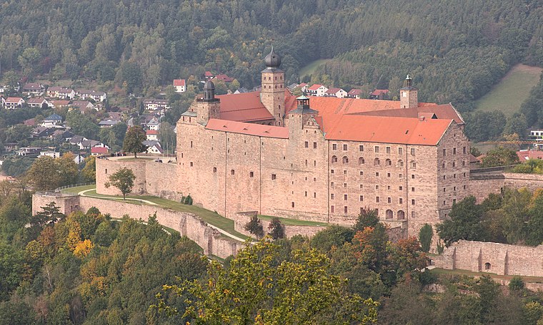
Photo: El Grafo, CC BY-SA 4.0.
Plassenburg is a castle in the city of Kulmbach in Bavaria. It is one of the most impressive castles in Germany and a symbol of the city. It was first mentioned in 1135. Plassenburg is situated 2 km east of Ireks GmbH Backmittel & Malz.
St. Nikolai
Church

Photo: Benreis, CC BY-SA 3.0.
St. Nikolai is a church, which is situated 1 km east of Ireks GmbH Backmittel & Malz.
Evangelische
Church

Photo: Benreis, CC BY-SA 3.0.
Evangelische is a church, which is situated 1 km south of Ireks GmbH Backmittel & Malz.
Places in the Area
Nearby places include Petzmannsberg and Ziegelhütten (Kulmbach).


Ireks GmbH Backmittel & Malz
- Type: Industry
- Location: Kulmbach, Kulmbach, Upper Franconia, Franconia, Bavaria, Germany, Central Europe, Europe
- View on OpenStreetMap
Latitude
50.10617° or 50° 6′ 22″ northLongitude
11.43774° or 11° 26′ 16″ eastOpen location code
9F2H4C4Q+F3OpenStreetMap ID
way 204686144OpenStreetMap feature
landuse=industrial
This page is based on OpenStreetMap, Wikidata, and Wikimedia Commons.
We’d love your help improving our open data sources. Thank you for contributing.
Satellite Map
Discover Ireks GmbH Backmittel & Malz from above in high-definition satellite imagery.
Notable Places Nearby
Highlights include Finanzamt Kulmbach and Vermessungsamt.
Nearby Places
Explore places such as IREKS Mitarbeiterparkplatz and Martina Klein.
Upper Franconia: Must-Visit Destinations
Delve into Bamberg, Bayreuth, Coburg, and Hof.
Curious Places to Discover
Uncover intriguing places from every corner of the globe.
About Mapcarta. Data © OpenStreetMap contributors and available under the Open Database License". Text is available under the CC BY-SA 4.0 license, except for photos, directions, and the map. Photo: Wikimedia, CC0.