71
71 is a pitch in Manhattan, New York. 71 is situated nearby to the pitch 81, as well as near the hospital George Rosenfeld Center for Recovery.| Tap on a place to explore it |
Places of Interest Nearby
Highlights include Robert F Kennedy Memorial Bridge and Wards Island.
Robert F Kennedy Memorial Bridge
Bridge

Photo: Wikimedia, CC BY-SA 3.0.
The Robert F. Kennedy Bridge is a complex of bridges and elevated expressway viaducts in New York City. The bridges link the boroughs of Manhattan, Queens, and the Bronx. Robert F Kennedy Memorial Bridge is situated 1,600 feet southeast of 71.
Wards Island
Island
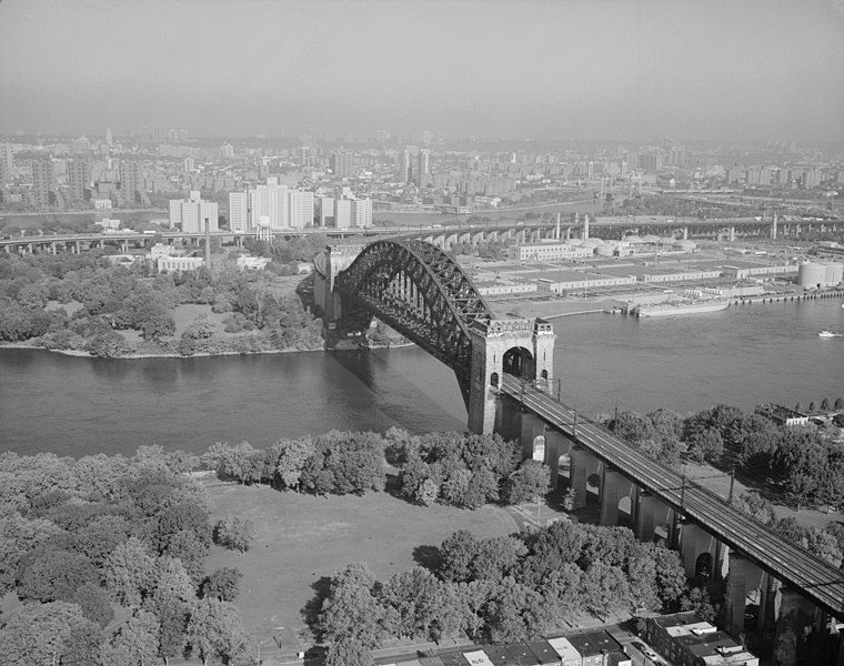
Photo: Wikimedia, Public domain.
Randalls Island and Wards Island are conjoined islands, collectively called Randalls and Wards Island, in New York City. Part of the borough of Manhattan, it is separated from Manhattan Island by the Harlem River, from Queens by the East River and Hell Gate, and from the Bronx by the Bronx Kill.
East River Arch Bridge of the New York Connecting Railroad
Bridge

Photo: Rhododendrites, CC BY-SA 4.0.
The Hell Gate Bridge is a railroad bridge in New York City. The bridge carries two tracks of Amtrak's Northeast Corridor and one freight track between Astoria, Queens, and Port Morris, Bronx, via Randalls and Wards Islands. East River Arch Bridge of the New York Connecting Railroad is situated 2,300 feet east of 71.
Places in the Area
Nearby places include Astoria and East Harlem.
Astoria
Neighborhood

Photo: Dinker022089, CC BY-SA 4.0.
Astoria is a neighborhood in the western portion of the New York City borough of Queens. Astoria is bounded by the East River and is adjacent to four other Queens neighborhoods: Long Island City to the southwest, Sunnyside to the southeast, and Woodside and East Elmhurst to the east.
East Harlem
Neighborhood

Photo: Diensthuber, CC BY 3.0.
East Harlem, also known as Spanish Harlem, or El Barrio, is a neighborhood of Upper Manhattan in New York City, north of the Upper East Side and bounded by 96th Street to the south, Fifth Avenue to the west, and the East and Harlem Rivers to the east and north.
Upper East Side

Photo: Alex Proimos, CC BY 2.0.
The Upper East Side of Manhattan is one of the city's wealthiest districts. Spanning the stretch of island between 59th Street to 96th Street east of Central Park, the neighborhoods of Lenox Hill, Yorkville, and Carnegie Hill are full of luxurious townhouses and apartment buildings on some of the most affluent addresses in New York.
71
- Type: Pitch
- Categories: recreation area, football, and sports location
- Location: Manhattan, New York, Mid-Atlantic, United States, North America
- View on OpenStreetMap
Latitude
40.78328° or 40° 46′ 60″ northLongitude
-73.93033° or 73° 55′ 49″ westOpen location code
87G8Q3M9+8VOpenStreetMap ID
way 207187329OpenStreetMap feature
leisure=pitchOpenStreetMap feature
sport=soccer
This page is based on OpenStreetMap, Wikidata, and Wikimedia Commons.
We’d love your help improving our open data sources. Thank you for contributing.
Satellite Map
Discover 71 from above in high-definition satellite imagery.
Notable Places Nearby
Highlights include 81 and George Rosenfeld Center for Recovery.
Nearby Places
Explore places such as Citi Bike - Wards Meadow Comfort Station and Hell Gate Circle/Odyssy House.
Manhattan: Must-Visit Destinations
Delve into Central Park, Upper East Side, Theater District, and Upper West Side.
Curious Pitches to Discover
Uncover intriguing pitches from every corner of the globe.
About Mapcarta. Data © OpenStreetMap contributors and available under the Open Database License". Text is available under the CC BY-SA 4.0 license, except for photos, directions, and the map. Photo: Wikimedia, CC BY-SA 3.0.