Kirche Jesu Christi der Heiligen der Letzten Tage
Kirche Jesu Christi der Heiligen der Letzten Tage is a church in Darmstadt, Wissenschaftsstadt, Darmstadt, Hesse. Kirche Jesu Christi der Heiligen der Letzten Tage is situated nearby to the church Thomasgemeinde, as well as near Borngässerplatz.| Tap on a place to explore it |
Places of Interest Nearby
Highlights include Vortex Garden and Oetingervilla.
Vortex Garden
Garden
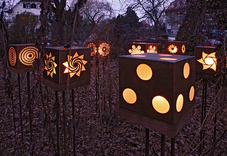
Photo: Reibundweise, CC BY-SA 3.0.
The Vortex Garden is a privately owned public garden in the Hessian city of Darmstadt. It is a pantheistic permaculture garden at the art nouveau area of Mathildenhöhe and alludes to Viktor Schauberger’s discovery of “levitational force” through artistic depictions by internationally renowned sculptors including John Wilkes, Jacopo Foggini, Jerome Abel Seguin and Hyesung Hyun. Vortex Garden is situated 1½ km southwest of Kirche Jesu Christi der Heiligen der Letzten Tage.
Oetingervilla
Community center

Photo: Wikimedia, CC BY-SA 3.0 de.
Oetingervilla is a community center, which is situated 1 km west of Kirche Jesu Christi der Heiligen der Letzten Tage.
Rosenhöhe Park
Park

Photo: Heidas, CC BY-SA 3.0.
Rosenhöhe Park is a park in eastern Darmstadt, standing on a hill. It contains a rose garden, with a rose dome at its highest point, the remains of the Rosenhöhe Palace, the mausoleums of the Hessian grand-ducal family, meadows, orchards, and many tree species, including sequoias. Rosenhöhe Park is situated 1 km south of Kirche Jesu Christi der Heiligen der Letzten Tage.
Places in the Area
Nearby places include Steubenplatz and Bessungen.
Steubenplatz
Locality

Photo: Erkaha, CC BY-SA 4.0.
Steubenplatz is a locality, which is situated 3 km southwest of Kirche Jesu Christi der Heiligen der Letzten Tage.
Bessungen
Quarter

Photo: Wikimedia, CC BY-SA 3.0.
Bessungen is a district in the South of the city of Darmstadt in Hesse. Bessungen is situated 3½ km southwest of Kirche Jesu Christi der Heiligen der Letzten Tage.
Kirche Jesu Christi der Heiligen der Letzten Tage
- Type: Church
- Denomination: Mormon
- Categories: building, place of worship, and religion
- Location: Darmstadt, Wissenschaftsstadt, Darmstadt, South Hesse, Hesse, Germany, Central Europe, Europe
- View on OpenStreetMap
Latitude
49.88602° or 49° 53′ 10″ northLongitude
8.67915° or 8° 40′ 45″ eastOpen location code
8FXCVMPH+CMOpenStreetMap ID
way 209529061OpenStreetMap feature
amenity=place_of_worshipOpenStreetMap feature
building=churchOpenStreetMap attribute
denomination=mormon
This page is based on OpenStreetMap, Wikidata, and Wikimedia Commons.
We’d love your help improving our open data sources. Thank you for contributing.
Satellite Map
Discover Kirche Jesu Christi der Heiligen der Letzten Tage from above in high-definition satellite imagery.
Places with the Same Name
Discover other places named “Kirche Jesu Christi der Heiligen der Letzten Tage”.
Notable Places Nearby
Highlights include Thomasgemeinde and Borngässerplatz.
Nearby Places
Explore places such as Terrassenhaus and Physiotherapie-Praxis Flotowstraße.
South Hesse: Must-Visit Destinations
Delve into Bensheim, Lorsch, Heppenheim, and Dreieich.
Curious Churches to Discover
Uncover intriguing churches from every corner of the globe.
About Mapcarta. Data © OpenStreetMap contributors and available under the Open Database License". Text is available under the CC BY-SA 4.0 license, except for photos, directions, and the map. Photo: Inkey, Public domain.