Stade Avenue de la Paix
Stade Avenue de la Paix is a pitch in Amiens, Somme, Hauts-de-France. Stade Avenue de la Paix is situated nearby to the community center Centre Social et Interculturel ALCO, as well as near the police station Police Nationale.| Tap on a place to explore it |
Places of Interest Nearby
Highlights include Amiens Cathedral and Église Sainte-Thérèse-de-l’Enfant-Jésus d’Amiens.
Amiens Cathedral
Church
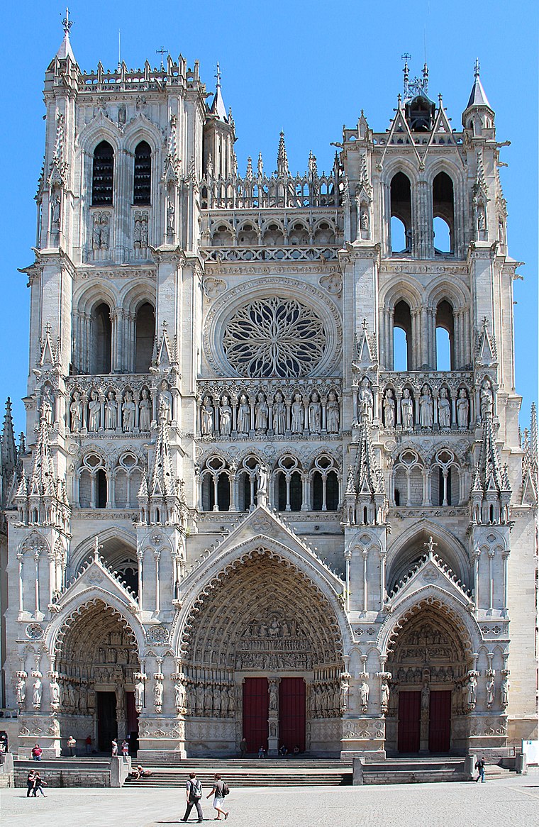
Photo: Jean-Pol GRANDMONT, CC BY 3.0.
The Cathedral of Our Lady of Amiens, or simply Amiens Cathedral, is a Catholic cathedral. The cathedral is the seat of the Bishop of Amiens. It is situated on a slight ridge overlooking the River Somme in Amiens, the administrative capital of the Picardy region of France, some 120 kilometres north of Paris. Amiens Cathedral is situated 2 km south of Stade Avenue de la Paix.
Église Sainte-Thérèse-de-l’Enfant-Jésus d’Amiens
Church

Photo: Ybroc, CC BY-SA 4.0.
Église Sainte-Thérèse-de-l’Enfant-Jésus d’Amiens is a church, which is situated 460 metres east of Stade Avenue de la Paix.
Citadelle d’Amiens
Castle
Photo: HaguardDuNord, CC BY 3.0.
Citadelle d’Amiens is a castle, which is situated 640 metres south of Stade Avenue de la Paix.
Places in the Area
Nearby places include Dreuil-lès-Amiens and Saveuse.
Dreuil-lès-Amiens
Village

Photo: Markus3, CC BY-SA 3.0.
Dreuil-lès-Amiens is a commune in the Somme department in Hauts-de-France in northern France. Dreuil-lès-Amiens is situated 4½ km west of Stade Avenue de la Paix.
Saveuse
Village

Photo: Markus3, CC BY-SA 2.5.
Saveuse is a commune in the Somme department in Hauts-de-France in northern France. Saveuse is situated 6 km west of Stade Avenue de la Paix.
Villers-Bocage
Village

Photo: François Ansart, CC BY-SA 4.0.
Villers-Bocage is a commune in the Somme department in Hauts-de-France in northern France. Villers-Bocage is situated 10 km north of Stade Avenue de la Paix.
Stade Avenue de la Paix
- Type: Pitch
- Categories: recreation area, football, and sports location
- Location: Amiens, Arrondissement of Amiens, Somme, Hauts-de-France, France, Europe
- View on OpenStreetMap
Latitude
49.91035° or 49° 54′ 37″ northLongitude
2.29868° or 2° 17′ 55″ eastOpen location code
8FX4W76X+4FOpenStreetMap ID
way 210565007OpenStreetMap feature
leisure=pitchOpenStreetMap feature
sport=soccer
This page is based on OpenStreetMap, Wikidata, and Wikimedia Commons.
We’d love your help improving our open data sources. Thank you for contributing.
Satellite Map
Discover Stade Avenue de la Paix from above in high-definition satellite imagery.
Notable Places Nearby
Highlights include Centre Social et Interculturel ALCO and Police Nationale.
Nearby Places
Explore places such as École primaire Émile Lesot Groupe B and École primaire Emile Lesot Groupe A.
Hauts-de-France: Must-Visit Destinations
Delve into Lille, Dunkirk, Calais, and Arras.
Curious Pitches to Discover
Uncover intriguing pitches from every corner of the globe.
About Mapcarta. Data © OpenStreetMap contributors and available under the Open Database License". Text is available under the CC BY-SA 4.0 license, except for photos, directions, and the map. Photo: Jean-Pol GRANDMONT, CC BY-SA 3.0.